Chegutu geodata
Chegutu (Mashonaland West) is a populated place; located in Zimbabwe in Africa/Harare (GMT+2) time zone. With population of 47,294 people, there are 12 cities with bigger population in this country. Compared to other cities in Zimbabwe, 60% of cities are located further ↓South; 60% of cities are located further →East and 52.3% of cities have higher elevation than Chegutu. Note1


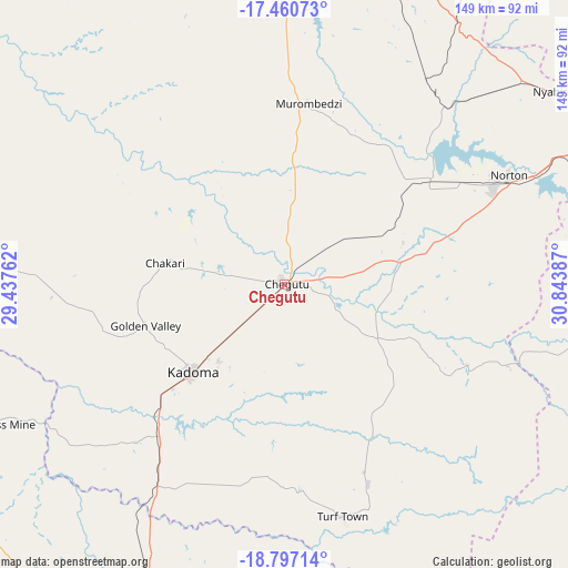
Chegutu GPS coordinates[2]
18° 7' 48.756" South, 30° 8' 26.664" East
| Map corner | latitude | longitude |
|---|---|---|
| Upper-left | -17.46073°, | 29.43762° |
| Center: | -18.13021°, | 30.14074° |
| Lower-right: | -18.79714°, | 30.84387° |
| Map W x H: | 148.6×148.6 km | = 92.3×92.3mi |
| max Lat: | -16.03333° ⇑40% North |
| Chegutu: | -18.13021° |
| min Lat: | ⇓60% South -22.21667° |
| min Long | Chegutu | max Long |
| 25.83066° | 30.14074° | 32.86667° |
| W 40%⇐ | ⇒60% E |
Elevation
Elevation of Chegutu is 1187 m = 3894 ft, and this is 10.7 m = 35 ft below average elevation for this country.
| Max E: |
1706 m = 5597 ft | 52.3% |
| Avg. | 1197.7 m = 3929 ft | |
| Chegutu | 1187 m = 3894 ft | |
Min E: |
402 m = 1319 ft | 47.7% |
See also: Chegutu elevation on elevation.city.
Geographical zone
Chegutu is located in South Torrid zone (between Equator and Tropic of Capricorn). Distance of this Southern Tropic circle is 590 km =366.6 mi to South.| Distance of | km | miles | from Chegutu |
|---|---|---|---|
| Equator | 2015.9 | 1252.6 | to North |
| Tropic Capricorn | 590 | 366.6 | to South |
| Antarctic Circle | 5385.3 | 3346.3 | to South |
| South Pole | 7991.2 | 4965.5 | to South |


Nearby cities:
15 places around Chegutu: (largest is in red/bold)
• Banket
87.5 km =54.4 mi,  18°
18°
• Beatrice
75.9 km =47.2 mi,  100°
100°
• Chakari
27.3 km =17 mi,  285°
285°
• Chinhoyi
85.1 km =52.9 mi,  4°
4°
• Chitungwiza
99.7 km =62 mi,  82°
82°
• Concession
119.3 km =74.1 mi,  45°
45°
• Epworth
109.8 km =68.2 mi, 75°
• Harare
102.2 km =63.5 mi,  70°
70°
• Kadoma
32.8 km =20.4 mi,  226°
226°
• Kwekwe
95.1 km =59.1 mi,  201°
201°
• Mazowe
112.4 km =69.8 mi, 51°
• Norton
65.2 km =40.5 mi, 65°
• Raffingora
125.8 km =78.2 mi,  14°
14°
• Redcliff
107.3 km =66.7 mi, 200°
• Ruwa
119.8 km =74.4 mi, 77°
Sources, notices
• [Note1] Compared only with cities in Zimbabwe existing in our database
• [Src1] Map data: © OpenStreetMap contributors (CC-BY-SA)
• [Src2] Other city data from geonames.org with taken over terms of usage.
• [Src3] Geographical zone / Annual Mean Temperature by Robert A. Rohde @ Wikipedia
