Mazowe geodata
Mazowe (Mashonaland Central) is a populated place; located in Zimbabwe in Africa/Harare (GMT+2) time zone. With population of 9,966 people, there are 31 cities with bigger population in this country. Compared to other cities in Zimbabwe, 75.4% of cities are located further ↓South; 61.5% of cities are located further ←West and 55.4% of cities have lower elevation than Mazowe. Note1


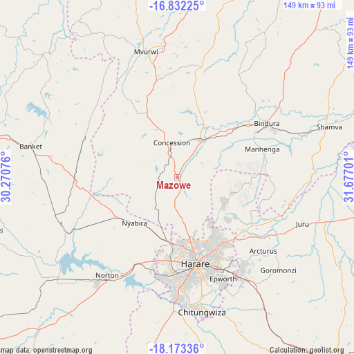
Mazowe GPS coordinates[2]
17° 30' 14.544" South, 30° 58' 25.968" East
| Map corner | latitude | longitude |
|---|---|---|
| Upper-left | -16.83225°, | 30.27076° |
| Center: | -17.50404°, | 30.97388° |
| Lower-right: | -18.17336°, | 31.67701° |
| Map W x H: | 149.1×149.1 km | = 92.6×92.6mi |
| max Lat: | -16.03333° ⇑24.6% North |
| Mazowe: | -17.50404° |
| min Lat: | ⇓75.4% South -22.21667° |
| min Long | Mazowe | max Long |
| 25.83066° | 30.97388° | 32.86667° |
| W 61.5%⇐ | ⇒38.5% E |
Elevation
Elevation of Mazowe is 1249 m = 4098 ft, and this is 51.3 m = 168 ft above average elevation for this country.
| Max E: |
1706 m = 5597 ft | 44.6% |
| Mazowe | 1249 m 4098 ft | |
| Avg. | 1197.7 m = 3929 ft | |
Min E: |
402 m = 1319 ft | 55.4% |
See also: Zimbabwe elevation on elevation.city.
Geographical zone
Mazowe is located in South Torrid zone (between Equator and Tropic of Capricorn). Distance of this Southern Tropic circle is 659.7 km =409.9 mi to South.| Distance of | km | miles | from Mazowe |
|---|---|---|---|
| Equator | 1946.3 | 1209.4 | to North |
| Tropic Capricorn | 659.7 | 409.9 | to South |
| Antarctic Circle | 5454.9 | 3389.5 | to South |
| South Pole | 8060.8 | 5008.7 | to South |


Nearby cities:
15 places around Mazowe: (largest is in red/bold)
• Banket
62.3 km =38.7 mi,  282°
282°
• Beatrice
84.3 km =52.4 mi,  189°
189°
• Bindura
44 km =27.3 mi,  59°
59°
• Chinhoyi
83.5 km =51.9 mi, 280°
• Chitungwiza
57.6 km =35.8 mi,  169°
169°
• Concession
13.7 km =8.5 mi,  349°
349°
• Epworth
46.7 km =29 mi,  156°
156°
• Glendale
19.3 km =12 mi,  30°
30°
• Harare
37 km =23 mi, 166°
• Murehwa
87.3 km =54.2 mi,  100°
100°
• Mvurwi
54 km =33.6 mi, 345°
• Norton
51.2 km =31.8 mi,  214°
214°
• Raffingora
77.7 km =48.3 mi,  312°
312°
• Ruwa
51.6 km =32.1 mi,  146°
146°
• Shamva
67.3 km =41.8 mi,  71°
71°
Sources, notices
• [Note1] Compared only with cities in Zimbabwe existing in our database
• [Src1] Map data: © OpenStreetMap contributors (CC-BY-SA)
• [Src2] Other city data from geonames.org with taken over terms of usage.
• [Src3] Geographical zone / Annual Mean Temperature by Robert A. Rohde @ Wikipedia
