Raffingora geodata
Raffingora (Mashonaland West) is a populated place; located in Zimbabwe in Africa/Harare (GMT+2) time zone. With population of 1,957 people, there are 56 cities with bigger population in this country. Compared to other cities in Zimbabwe, 87.7% of cities are located further ↓South; 52.3% of cities are located further →East and 60% of cities have higher elevation than Raffingora. Note1


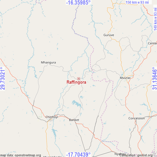
Raffingora GPS coordinates[2]
17° 1' 59.988" South, 30° 25' 59.988" East
| Map corner | latitude | longitude |
|---|---|---|
| Upper-left | -16.35985°, | 29.73021° |
| Center: | -17.03333°, | 30.43333° |
| Lower-right: | -17.70439°, | 31.13646° |
| Map W x H: | 149.5×149.5 km | = 92.9×92.9mi |
| max Lat: | -16.03333° ⇑12.3% North |
| Raffingora: | -17.03333° |
| min Lat: | ⇓87.7% South -22.21667° |
| min Long | Raffingora | max Long |
| 25.83066° | 30.43333° | 32.86667° |
| W 47.7%⇐ | ⇒52.3% E |
Elevation
Elevation of Raffingora is 1160 m = 3806 ft, and this is 37.7 m = 124 ft below average elevation for this country.
| Max E: |
1706 m = 5597 ft | 60% |
| Avg. | 1197.7 m = 3929 ft | |
| Raffingora | 1160 m = 3806 ft | |
Min E: |
402 m = 1319 ft | 40% |
See also: Zimbabwe elevation on elevation.city.
Geographical zone
Raffingora is located in South Torrid zone (between Equator and Tropic of Capricorn). Distance of this Southern Tropic circle is 712 km =442.4 mi to South.| Distance of | km | miles | from Raffingora |
|---|---|---|---|
| Equator | 1893.9 | 1176.8 | to North |
| Tropic Capricorn | 712 | 442.4 | to South |
| Antarctic Circle | 5507.2 | 3422 | to South |
| South Pole | 8113.1 | 5041.2 | to South |


Nearby cities:
15 places around Raffingora: (largest is in red/bold)
• Banket
39.1 km =24.3 mi,  185°
185°
• Bindura
99.9 km =62.1 mi,  107°
107°
• Centenary
80.3 km =49.9 mi,  64°
64°
• Chinhoyi
44.6 km =27.7 mi,  213°
213°
• Concession
67.3 km =41.8 mi,  125°
125°
• Epworth
121.7 km =75.6 mi,  141°
141°
• Glendale
76.2 km =47.3 mi,  117°
117°
• Harare
110.1 km =68.4 mi, 143°
• Karoi
82.6 km =51.3 mi,  287°
287°
• Madziwa
117.7 km =73.1 mi,  83°
83°
• Mazowe
77.7 km =48.3 mi, 132°
• Mhangura
32.2 km =20 mi,  298°
298°
• Mvurwi
44.3 km =27.5 mi,  90°
90°
• Norton
98.7 km =61.3 mi,  163°
163°
• Shamva
125.2 km =77.8 mi,  104°
104°
Sources, notices
• [Note1] Compared only with cities in Zimbabwe existing in our database
• [Src1] Map data: © OpenStreetMap contributors (CC-BY-SA)
• [Src2] Other city data from geonames.org with taken over terms of usage.
• [Src3] Geographical zone / Annual Mean Temperature by Robert A. Rohde @ Wikipedia
