Norton geodata
Norton (Mashonaland West) is a populated place; located in Zimbabwe in Africa/Harare (GMT+2) time zone. With population of 52,054 people, there are 11 cities with bigger population in this country. Compared to other cities in Zimbabwe, 69.2% of cities are located further ↓South; 52.3% of cities are located further ←West and 67.7% of cities have lower elevation than Norton. Note1


Norton GPS coordinates[2]
17° 52' 59.988" South, 30° 42' 0" East
| Map corner | latitude | longitude |
|---|---|---|
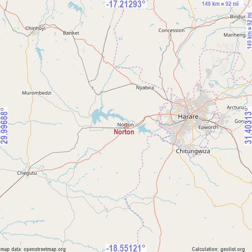
| Upper-left | -17.21293°, | 29.99688° |
| Center: | -17.88333°, | 30.7° |
| Lower-right: | -18.55121°, | 31.40313° |
| Map W x H: | 148.8×148.8 km | = 92.5×92.5mi |
| max Lat: | -16.03333° ⇑30.8% North |
| Norton: | -17.88333° |
| min Lat: | ⇓69.2% South -22.21667° |
| min Long | Norton | max Long |
| 25.83066° | 30.7° | 32.86667° |
| W 52.3%⇐ | ⇒47.7% E |
Elevation
Elevation of Norton is 1364 m = 4475 ft, and this is 166.3 m = 546 ft above average elevation for this country.
| Max E: |
1706 m = 5597 ft | 32.3% |
| Norton | 1364 m 4475 ft | |
| Avg. | 1197.7 m = 3929 ft | |
Min E: |
402 m = 1319 ft | 67.7% |
See also: Norton elevation on elevation.city.
Geographical zone
Norton is located in South Torrid zone (between Equator and Tropic of Capricorn). Distance of this Southern Tropic circle is 617.5 km =383.7 mi to South.| Distance of | km | miles | from Norton |
|---|---|---|---|
| Equator | 1988.4 | 1235.5 | to North |
| Tropic Capricorn | 617.5 | 383.7 | to South |
| Antarctic Circle | 5412.7 | 3363.3 | to South |
| South Pole | 8018.6 | 4982.5 | to South |


Nearby cities:
15 places around Norton: (largest is in red/bold)
• Banket
64 km =39.8 mi,  330°
330°
• Beatrice
43.9 km =27.3 mi,  159°
159°
• Bindura
93 km =57.8 mi,  45°
45°
• Chakari
87.7 km =54.5 mi,  256°
256°
• Chegutu
65.2 km =40.5 mi,  245°
245°
• Chinhoyi
78.2 km =48.6 mi,  317°
317°
• Chitungwiza
42.3 km =26.3 mi,  109°
109°
• Concession
61.6 km =38.3 mi,  25°
25°
• Epworth
47.4 km =29.5 mi,  90°
90°
• Glendale
70.4 km =43.7 mi, 33°
• Harare
37.9 km =23.5 mi,  80°
80°
• Marondera
96.1 km =59.7 mi, 110°
• Mazowe
51.2 km =31.8 mi, 34°
• Mvurwi
95.8 km =59.5 mi,  9°
9°
• Ruwa
57.6 km =35.8 mi, 90°
Sources, notices
• [Note1] Compared only with cities in Zimbabwe existing in our database
• [Src1] Map data: © OpenStreetMap contributors (CC-BY-SA)
• [Src2] Other city data from geonames.org with taken over terms of usage.
• [Src3] Geographical zone / Annual Mean Temperature by Robert A. Rohde @ Wikipedia
