Chinhoyi geodata
Chinhoyi (Mashonaland West) is a seat of a first-order administrative division; located in Zimbabwe in Africa/Harare (GMT+2) time zone. With population of 61,739 people, there are 9 cities with bigger population in this country. Compared to other cities in Zimbabwe, 81.5% of cities are located further ↓South; 55.4% of cities are located further →East and 61.5% of cities have higher elevation than Chinhoyi. Note1


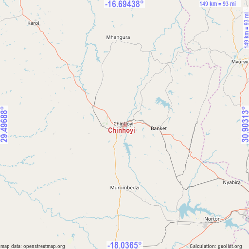
Chinhoyi GPS coordinates[2]
17° 22' 0.012" South, 30° 12' 0" East
| Map corner | latitude | longitude |
|---|---|---|
| Upper-left | -16.69438°, | 29.49688° |
| Center: | -17.36667°, | 30.2° |
| Lower-right: | -18.0365°, | 30.90313° |
| Map W x H: | 149.2×149.2 km | = 92.7×92.7mi |
| max Lat: | -16.03333° ⇑18.5% North |
| Chinhoyi: | -17.36667° |
| min Lat: | ⇓81.5% South -22.21667° |
| min Long | Chinhoyi | max Long |
| 25.83066° | 30.2° | 32.86667° |
| W 44.6%⇐ | ⇒55.4% E |
Elevation
Elevation of Chinhoyi is 1153 m = 3783 ft, and this is 44.7 m = 147 ft below average elevation for this country.
| Max E: |
1706 m = 5597 ft | 61.5% |
| Avg. | 1197.7 m = 3929 ft | |
| Chinhoyi | 1153 m = 3783 ft | |
Min E: |
402 m = 1319 ft | 38.5% |
See also: Chinhoyi elevation on elevation.city.
Geographical zone
Chinhoyi is located in South Torrid zone (between Equator and Tropic of Capricorn). Distance of this Southern Tropic circle is 674.9 km =419.4 mi to South.| Distance of | km | miles | from Chinhoyi |
|---|---|---|---|
| Equator | 1931 | 1199.9 | to North |
| Tropic Capricorn | 674.9 | 419.4 | to South |
| Antarctic Circle | 5470.2 | 3399 | to South |
| South Pole | 8076.1 | 5018.3 | to South |


Nearby cities:
15 places around Chinhoyi: (largest is in red/bold)
• Banket
21.3 km =13.2 mi,  94°
94°
• Chakari
84 km =52.2 mi,  202°
202°
• Chegutu
85.1 km =52.9 mi,  184°
184°
• Chitungwiza
117.3 km =72.9 mi,  127°
127°
• Concession
79.6 km =49.5 mi, 91°
• Epworth
116 km =72.1 mi,  120°
120°
• Glendale
92 km =57.2 mi, 89°
• Harare
104 km =64.6 mi, 119°
• Kadoma
111.6 km =69.3 mi, 195°
• Karoi
82.1 km =51 mi,  318°
318°
• Mazowe
83.5 km =51.9 mi,  100°
100°
• Mhangura
52.7 km =32.7 mi,  356°
356°
• Mvurwi
78.4 km =48.7 mi,  61°
61°
• Norton
78.2 km =48.6 mi,  137°
137°
• Raffingora
44.6 km =27.7 mi,  33°
33°
Sources, notices
• [Note1] Compared only with cities in Zimbabwe existing in our database
• [Src1] Map data: © OpenStreetMap contributors (CC-BY-SA)
• [Src2] Other city data from geonames.org with taken over terms of usage.
• [Src3] Geographical zone / Annual Mean Temperature by Robert A. Rohde @ Wikipedia
