Harare geodata
Harare is a capital of a political entity; located in Zimbabwe in Africa/Harare (GMT+2) time zone. With population of 1,542,813 people, there are 0 cities with bigger population in this country. Compared to other cities in Zimbabwe, 70.8% of cities are located further ↓South; 63.1% of cities are located further ←West and 86.2% of cities have lower elevation than Harare. Note1


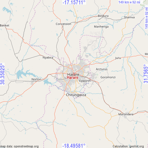
Harare GPS coordinates[2]
17° 49' 39.792" South, 31° 3' 12.132" East
| Map corner | latitude | longitude |
|---|---|---|
| Upper-left | -17.15711°, | 30.35025° |
| Center: | -17.82772°, | 31.05337° |
| Lower-right: | -18.49581°, | 31.7565° |
| Map W x H: | 148.8×148.9 km | = 92.5×92.5mi |
| max Lat: | -16.03333° ⇑29.2% North |
| Harare: | -17.82772° |
| min Lat: | ⇓70.8% South -22.21667° |
| min Long | Harare | max Long |
| 25.83066° | 31.05337° | 32.86667° |
| W 63.1%⇐ | ⇒36.9% E |
Elevation
Elevation of Harare is 1494 m = 4902 ft, and this is 296.3 m = 972 ft above average elevation for this country.
| Max E: |
1706 m = 5597 ft | 13.8% |
| Harare | 1494 m 4902 ft | |
| Avg. | 1197.7 m = 3929 ft | |
Min E: |
402 m = 1319 ft | 86.2% |
See also: Harare elevation on elevation.city.
Geographical zone
Harare is located in South Torrid zone (between Equator and Tropic of Capricorn). Distance of this Southern Tropic circle is 623.7 km =387.5 mi to South.| Distance of | km | miles | from Harare |
|---|---|---|---|
| Equator | 1982.3 | 1231.7 | to North |
| Tropic Capricorn | 623.7 | 387.5 | to South |
| Antarctic Circle | 5418.9 | 3367.1 | to South |
| South Pole | 8024.8 | 4986.4 | to South |


Nearby cities:
15 places around Harare: (largest is in red/bold)
• Banket
85.1 km =52.9 mi,  305°
305°
• Beatrice
52 km =32.3 mi,  204°
204°
• Bindura
65.4 km =40.6 mi,  26°
26°
• Chitungwiza
20.7 km =12.9 mi,  173°
173°
• Concession
50.6 km =31.4 mi,  347°
347°
• Epworth
12.1 km =7.5 mi,  124°
124°
• Glendale
52.6 km =32.7 mi,  1°
1°
• Macheke
91 km =56.5 mi,  112°
112°
• Marondera
66 km =41 mi,  127°
127°
• Mazowe
37 km =23 mi, 346°
• Murehwa
80.1 km =49.8 mi,  75°
75°
• Mvurwi
90.9 km =56.5 mi, 346°
• Norton
37.9 km =23.5 mi,  260°
260°
• Ruwa
21.4 km =13.3 mi, 108°
• Shamva
79.7 km =49.5 mi,  43°
43°
Sources, notices
• [Note1] Compared only with cities in Zimbabwe existing in our database
• [Src1] Map data: © OpenStreetMap contributors (CC-BY-SA)
• [Src2] Other city data from geonames.org with taken over terms of usage.
• [Src3] Geographical zone / Annual Mean Temperature by Robert A. Rohde @ Wikipedia
