Kadoma geodata
Kadoma (Mashonaland West) is a populated place; located in Zimbabwe in Africa/Harare (GMT+2) time zone. With population of 79,174 people, there are 7 cities with bigger population in this country. Compared to other cities in Zimbabwe, 52.3% of cities are located further ↑North; 66.2% of cities are located further →East and 58.5% of cities have higher elevation than Kadoma. Note1


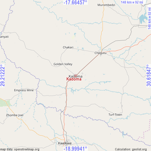
Kadoma GPS coordinates[2]
18° 19' 59.808" South, 29° 54' 55.224" East
| Map corner | latitude | longitude |
|---|---|---|
| Upper-left | -17.66457°, | 29.21222° |
| Center: | -18.33328°, | 29.91534° |
| Lower-right: | -18.99941°, | 30.61847° |
| Map W x H: | 148.4×148.4 km | = 92.2×92.2mi |
| max Lat: | -16.03333° ⇑52.3% North |
| Kadoma: | -18.33328° |
| min Lat: | ⇓47.7% South -22.21667° |
| min Long | Kadoma | max Long |
| 25.83066° | 29.91534° | 32.86667° |
| W 33.8%⇐ | ⇒66.2% E |
Elevation
Elevation of Kadoma is 1176 m = 3858 ft, and this is 21.7 m = 71 ft below average elevation for this country.
| Max E: |
1706 m = 5597 ft | 58.5% |
| Avg. | 1197.7 m = 3929 ft | |
| Kadoma | 1176 m = 3858 ft | |
Min E: |
402 m = 1319 ft | 41.5% |
See also: Kadoma elevation on elevation.city.
Geographical zone
Kadoma is located in South Torrid zone (between Equator and Tropic of Capricorn). Distance of this Southern Tropic circle is 567.4 km =352.6 mi to South.| Distance of | km | miles | from Kadoma |
|---|---|---|---|
| Equator | 2038.5 | 1266.7 | to North |
| Tropic Capricorn | 567.4 | 352.6 | to South |
| Antarctic Circle | 5362.7 | 3332.2 | to South |
| South Pole | 7968.6 | 4951.5 | to South |


Nearby cities:
15 places around Kadoma: (largest is in red/bold)
• Banket
117.4 km =72.9 mi,  25°
25°
• Beatrice
98.8 km =61.4 mi,  84°
84°
• Chakari
30.2 km =18.8 mi,  355°
355°
• Chegutu
32.8 km =20.4 mi,  46°
46°
• Chinhoyi
111.6 km =69.3 mi,  15°
15°
• Chitungwiza
127.6 km =79.3 mi,  73°
73°
• Chivhu
128.2 km =79.7 mi,  126°
126°
• Gokwe
104.5 km =64.9 mi,  277°
277°
• Gweru
124.6 km =77.4 mi,  184°
184°
• Harare
132.8 km =82.5 mi,  64°
64°
• Kwekwe
67 km =41.6 mi,  189°
189°
• Lalapanzi
114.5 km =71.1 mi,  166°
166°
• Mvuma
123.4 km =76.7 mi,  148°
148°
• Norton
96.8 km =60.1 mi, 58°
• Redcliff
79.1 km =49.2 mi, 190°
Sources, notices
• [Note1] Compared only with cities in Zimbabwe existing in our database
• [Src1] Map data: © OpenStreetMap contributors (CC-BY-SA)
• [Src2] Other city data from geonames.org with taken over terms of usage.
• [Src3] Geographical zone / Annual Mean Temperature by Robert A. Rohde @ Wikipedia
