Ḩāfiz̧ Moghul geodata
Ḩāfiz̧ Moghul (Badakhshan) is a seat of a second-order administrative division; located in Afghanistan in Asia/Kabul (GMT+4.5) time zone. In our database, there are 93 cities with bigger population. Compared to other cities in Afghanistan, 93.2% of cities are located further ↓South; 87.5% of cities are located further ←West and 62.4% of cities have lower elevation than Ḩāfiz̧ Moghul. Note1


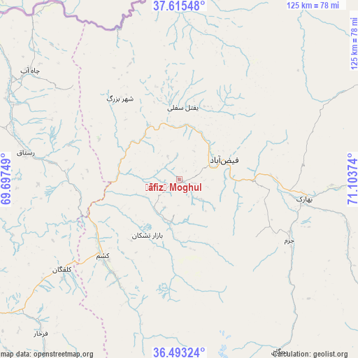
Ḩāfiz̧ Moghul GPS coordinates[2]
37° 3' 23.148" North, 70° 24' 2.196" East
| Map corner | latitude | longitude |
|---|---|---|
| Upper-left | 37.61548°, | 69.69749° |
| Center: | 37.05643°, | 70.40061° |
| Lower-right: | 36.49324°, | 71.10374° |
| Map W x H: | 124.8×124.8 km | = 77.5×77.5mi |
| max Lat: | 38.4435° ⇑6.8% North |
| Ḩāfiz̧ Moghul: | 37.05643° |
| min Lat: | ⇓93.2% South 30.15° |
| min Long | Ḩāfiz̧ Mogh | max Long |
| 61.06667° | 70.40061° | 72.318° |
| W 87.5%⇐ | ⇒12.5% E |
Elevation
Elevation of Ḩāfiz̧ Moghul is 1700 m = 5577 ft, and this is 281.6 m = 924 ft above average elevation for this country.
| Max E: |
3068 m = 10066 ft | 37.6% |
| Ḩāfiz̧ Moghul | 1700 m 5577 ft | |
| Avg. | 1418.4 m = 4654 ft | |
Min E: |
254 m = 833 ft | 62.4% |
See also: Afghanistan elevation on elevation.city.
Geographical zone
Ḩāfiz̧ Moghul is located in North temperate zone (between Tropic of Cancer and the Arctic Circle). Distance of this Northern Tropic circle is 1514.4 km =941 mi to South.| Distance of | km | miles | from Ḩāfiz̧ Moghul |
|---|---|---|---|
| North Pole | 5886.8 | 3657.9 | to North |
| Arctic Circle | 3280.9 | 2038.7 | to North |
| Tropic Cancer | 1514.4 | 941 | to South |
| Equator | 4120.3 | 2560.2 | to South |


Nearby cities:
15 places around Ḩāfiz̧ Moghul: (largest is in red/bold)
• Bahārak
45.3 km =28.1 mi,  97°
97°
• Bāzār-e Tashkān
22.3 km =13.9 mi,  209°
209°
• Chāh Āb
64.3 km =40 mi,  306°
306°
• Chākarān
61.5 km =38.2 mi,  105°
105°
• Darāyim
21.2 km =13.2 mi,  184°
184°
• Fayzabad
17.3 km =10.7 mi,  67°
67°
• Ghurayd Gharamē
68.8 km =42.8 mi,  149°
149°
• Jurm
44 km =27.3 mi,  118°
118°
• Kalafgān
51.4 km =31.9 mi,  232°
232°
• March
52.7 km =32.7 mi,  4°
4°
• Mashhad
37.6 km =23.4 mi,  224°
224°
• Pas Pul
50.1 km =31.1 mi,  22°
22°
• Rustāq
51.2 km =31.8 mi,  278°
278°
• Shahrān
31.2 km =19.4 mi, 105°
• Zīrakī
61.2 km =38 mi,  13°
13°
Sources, notices
• [Note1] Compared only with cities in Afghanistan existing in our database
• [Src1] Map data: © OpenStreetMap contributors (CC-BY-SA)
• [Src2] Other city data from geonames.org with taken over terms of usage.
• [Src3] Geographical zone / Annual Mean Temperature by Robert A. Rohde @ Wikipedia
