Dowlatābād geodata
Dowlatābād (Faryab) is a seat of a second-order administrative division; located in Afghanistan in Asia/Kabul (GMT+4.5) time zone. In our database, there are 93 cities with bigger population. Compared to other cities in Afghanistan, 80.4% of cities are located further ↓South; 81% of cities are located further →East and 92% of cities have higher elevation than Dowlatābād. Note1


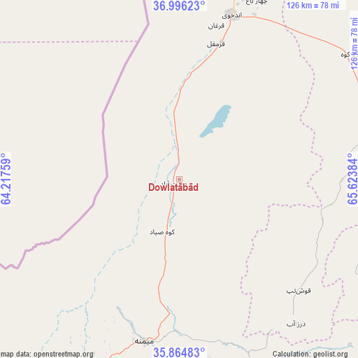
Dowlatābād GPS coordinates[2]
36° 25' 57.324" North, 64° 55' 14.556" East
| Map corner | latitude | longitude |
|---|---|---|
| Upper-left | 36.99623°, | 64.21759° |
| Center: | 36.43259°, | 64.92071° |
| Lower-right: | 35.86483°, | 65.62384° |
| Map W x H: | 125.8×125.8 km | = 78.2×78.2mi |
| max Lat: | 38.4435° ⇑19.6% North |
| Dowlatābād: | 36.43259° |
| min Lat: | ⇓80.4% South 30.15° |
| min Long | Dowlatābād | max Long |
| 61.06667° | 64.92071° | 72.318° |
| W 19%⇐ | ⇒81% E |
Elevation
Elevation of Dowlatābād is 413 m = 1355 ft, and this is 1005.4 m = 3299 ft below average elevation for this country.
| Max E: |
3068 m = 10066 ft | 92% |
| Avg. | 1418.4 m = 4654 ft | |
| Dowlatābād | 413 m = 1355 ft | |
Min E: |
254 m = 833 ft | 8% |
See also: Afghanistan elevation on elevation.city.
Geographical zone
Dowlatābād is located in North temperate zone (between Tropic of Cancer and the Arctic Circle). Distance of this Northern Tropic circle is 1445 km =897.9 mi to South.| Distance of | km | miles | from Dowlatābād |
|---|---|---|---|
| North Pole | 5956.1 | 3700.9 | to North |
| Arctic Circle | 3350.2 | 2081.7 | to North |
| Tropic Cancer | 1445 | 897.9 | to South |
| Equator | 4050.9 | 2517.1 | to South |


Nearby cities:
15 places around Dowlatābād: (largest is in red/bold)
• Andkhōy
60.6 km =37.7 mi,  17°
17°
• Bal Chirāgh
71.5 km =44.4 mi,  157°
157°
• Chahār Bāgh
68.7 km =42.7 mi, 23°
• Darzāb
65.2 km =40.5 mi,  140°
140°
• Fayẕābād
16.6 km =10.3 mi,  198°
198°
• Khwājah Dū Kōh
76.7 km =47.7 mi,  54°
54°
• Maymana
58.2 km =36.2 mi,  192°
192°
• Qaram Qōl
45.5 km =28.3 mi,  13°
13°
• Qurghān
55.6 km =34.5 mi, 13°
• Sangalak-i-Kaisar
100.2 km =62.3 mi,  214°
214°
• Sar Chakān
85.9 km =53.4 mi, 161°
• Sar-e Pul
93.8 km =58.3 mi,  104°
104°
• Shibirghān
78.8 km =49 mi,  70°
70°
• Şayād
87.9 km =54.6 mi,  112°
112°
• ‘Alāqahdārī-ye Almār
74 km =46 mi, 208°
Sources, notices
• [Note1] Compared only with cities in Afghanistan existing in our database
• [Src1] Map data: © OpenStreetMap contributors (CC-BY-SA)
• [Src2] Other city data from geonames.org with taken over terms of usage.
• [Src3] Geographical zone / Annual Mean Temperature by Robert A. Rohde @ Wikipedia
