Andkhōy geodata
Andkhōy (Faryab) is a seat of a second-order administrative division; located in Afghanistan in Asia/Kabul (GMT+4.5) time zone. With population of 29,208 people, there are 31 cities with bigger population in this country. Compared to other cities in Afghanistan, 90.7% of cities are located further ↓South; 79.4% of cities are located further →East and 97.4% of cities have higher elevation than Andkhōy. Note1


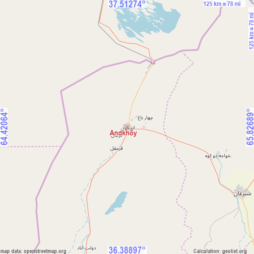
Andkhōy GPS coordinates[2]
36° 57' 10.548" North, 65° 7' 25.536" East
| Map corner | latitude | longitude |
|---|---|---|
| Upper-left | 37.51274°, | 64.42064° |
| Center: | 36.95293°, | 65.12376° |
| Lower-right: | 36.38897°, | 65.82689° |
| Map W x H: | 125×125 km | = 77.7×77.7mi |
| max Lat: | 38.4435° ⇑9.3% North |
| Andkhōy: | 36.95293° |
| min Lat: | ⇓90.7% South 30.15° |
| min Long | Andkhōy | max Long |
| 61.06667° | 65.12376° | 72.318° |
| W 20.6%⇐ | ⇒79.4% E |
Elevation
Elevation of Andkhōy is 306 m = 1004 ft, and this is 1112.4 m = 3650 ft below average elevation for this country.
| Max E: |
3068 m = 10066 ft | 97.4% |
| Avg. | 1418.4 m = 4654 ft | |
| Andkhōy | 306 m = 1004 ft | |
Min E: |
254 m = 833 ft | 2.6% |
See also: Afghanistan elevation on elevation.city.
Geographical zone
Andkhōy is located in North temperate zone (between Tropic of Cancer and the Arctic Circle). Distance of this Northern Tropic circle is 1502.9 km =933.9 mi to South.| Distance of | km | miles | from Andkhōy |
|---|---|---|---|
| North Pole | 5898.3 | 3665 | to North |
| Arctic Circle | 3292.4 | 2045.8 | to North |
| Tropic Cancer | 1502.9 | 933.9 | to South |
| Equator | 4108.8 | 2553.1 | to South |


Nearby cities:
15 places around Andkhōy: (largest is in red/bold)
• Chahār Bāgh
10.4 km =6.5 mi,  58°
58°
• Dowlatābād
60.6 km =37.7 mi,  197°
197°
• Fayẕābād
77.2 km =48 mi, 197°
• Khamyāb
85.1 km =52.9 mi,  41°
41°
• Khwājah Dū Kōh
46.6 km =29 mi,  107°
107°
• Khānaqāh
93.3 km =58 mi,  96°
96°
• Mardīān
104.3 km =64.8 mi,  87°
87°
• Mingajik
89.6 km =55.7 mi,  84°
84°
• Qaram Qōl
15.4 km =9.6 mi,  207°
207°
• Qarqīn
96.5 km =60 mi, 57°
• Qurghān
6.4 km =4 mi,  234°
234°
• Sar-e Pul
109.3 km =67.9 mi,  138°
138°
• Shibirghān
64.4 km =40 mi,  119°
119°
• Āqchah
94.3 km =58.6 mi, 93°
• Şayād
110.6 km =68.7 mi,  145°
145°
Sources, notices
• [Note1] Compared only with cities in Afghanistan existing in our database
• [Src1] Map data: © OpenStreetMap contributors (CC-BY-SA)
• [Src2] Other city data from geonames.org with taken over terms of usage.
• [Src3] Geographical zone / Annual Mean Temperature by Robert A. Rohde @ Wikipedia
