Mingajik geodata
Mingajik (Jowzjan) is a seat of a second-order administrative division; located in Afghanistan in Asia/Kabul (GMT+4.5) time zone. In our database, there are 93 cities with bigger population. Compared to other cities in Afghanistan, 92.6% of cities are located further ↓South; 70.7% of cities are located further →East and 99.4% of cities have higher elevation than Mingajik. Note1


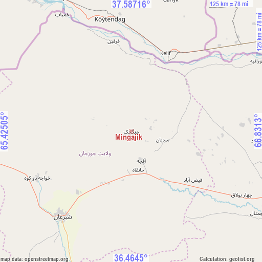
Mingajik GPS coordinates[2]
37° 1' 40.44" North, 66° 7' 41.412" East
| Map corner | latitude | longitude |
|---|---|---|
| Upper-left | 37.58716°, | 65.42505° |
| Center: | 37.0279°, | 66.12817° |
| Lower-right: | 36.4645°, | 66.8313° |
| Map W x H: | 124.8×124.8 km | = 77.5×77.5mi |
| max Lat: | 38.4435° ⇑7.4% North |
| Mingajik: | 37.0279° |
| min Lat: | ⇓92.6% South 30.15° |
| min Long | Mingajik | max Long |
| 61.06667° | 66.12817° | 72.318° |
| W 29.3%⇐ | ⇒70.7% E |
Elevation
Elevation of Mingajik is 280 m = 919 ft, and this is 1138.4 m = 3735 ft below average elevation for this country.
| Max E: |
3068 m = 10066 ft | 99.4% |
| Avg. | 1418.4 m = 4654 ft | |
| Mingajik | 280 m = 919 ft | |
Min E: |
254 m = 833 ft | 0.6% |
See also: Afghanistan elevation on elevation.city.
Geographical zone
Mingajik is located in North temperate zone (between Tropic of Cancer and the Arctic Circle). Distance of this Northern Tropic circle is 1511.2 km =939 mi to South.| Distance of | km | miles | from Mingajik |
|---|---|---|---|
| North Pole | 5889.9 | 3659.8 | to North |
| Arctic Circle | 3284.1 | 2040.6 | to North |
| Tropic Cancer | 1511.2 | 939 | to South |
| Equator | 4117.1 | 2558.2 | to South |


Nearby cities:
15 places around Mingajik: (largest is in red/bold)
• Andkhōy
89.6 km =55.7 mi,  264°
264°
• Balkh
74.8 km =46.5 mi,  113°
113°
• Chahār Bāgh
80.3 km =49.9 mi,  267°
267°
• Chimtāl
71.6 km =44.5 mi,  122°
122°
• Dehdādī
87 km =54.1 mi, 117°
• Dowlatābād
61.6 km =38.3 mi,  94°
94°
• Faīẕābād
37.4 km =23.2 mi,  128°
128°
• Khamyāb
64.5 km =40.1 mi,  329°
329°
• Khwājah Dū Kōh
50 km =31.1 mi,  243°
243°
• Khānaqāh
18.7 km =11.6 mi,  169°
169°
• Mardīān
15.5 km =9.6 mi,  104°
104°
• Qarchī Gak
58.7 km =36.5 mi, 88°
• Qarqīn
44.1 km =27.4 mi,  350°
350°
• Shibirghān
52.2 km =32.4 mi,  219°
219°
• Āqchah
14.5 km =9 mi,  160°
160°
Sources, notices
• [Note1] Compared only with cities in Afghanistan existing in our database
• [Src1] Map data: © OpenStreetMap contributors (CC-BY-SA)
• [Src2] Other city data from geonames.org with taken over terms of usage.
• [Src3] Geographical zone / Annual Mean Temperature by Robert A. Rohde @ Wikipedia
