Mardīān geodata
Mardīān (Jowzjan) is a seat of a second-order administrative division; located in Afghanistan in Asia/Kabul (GMT+4.5) time zone. In our database, there are 93 cities with bigger population. Compared to other cities in Afghanistan, 91.6% of cities are located further ↓South; 67.8% of cities are located further →East and 98.7% of cities have higher elevation than Mardīān. Note1


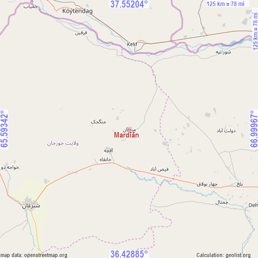
Mardīān GPS coordinates[2]
36° 59' 33.072" North, 66° 17' 47.544" East
| Map corner | latitude | longitude |
|---|---|---|
| Upper-left | 37.55204°, | 65.59342° |
| Center: | 36.99252°, | 66.29654° |
| Lower-right: | 36.42885°, | 66.99967° |
| Map W x H: | 124.9×124.9 km | = 77.6×77.6mi |
| max Lat: | 38.4435° ⇑8.4% North |
| Mardīān: | 36.99252° |
| min Lat: | ⇓91.6% South 30.15° |
| min Long | Mardīān | max Long |
| 61.06667° | 66.29654° | 72.318° |
| W 32.2%⇐ | ⇒67.8% E |
Elevation
Elevation of Mardīān is 287 m = 942 ft, and this is 1131.4 m = 3712 ft below average elevation for this country.
| Max E: |
3068 m = 10066 ft | 98.7% |
| Avg. | 1418.4 m = 4654 ft | |
| Mardīān | 287 m = 942 ft | |
Min E: |
254 m = 833 ft | 1.3% |
See also: Afghanistan elevation on elevation.city.
Geographical zone
Mardīān is located in North temperate zone (between Tropic of Cancer and the Arctic Circle). Distance of this Northern Tropic circle is 1507.3 km =936.6 mi to South.| Distance of | km | miles | from Mardīān |
|---|---|---|---|
| North Pole | 5893.9 | 3662.3 | to North |
| Arctic Circle | 3288 | 2043.1 | to North |
| Tropic Cancer | 1507.3 | 936.6 | to South |
| Equator | 4113.2 | 2555.8 | to South |


Nearby cities:
15 places around Mardīān: (largest is in red/bold)
• Balkh
59.5 km =37 mi,  116°
116°
• Chimtāl
57.1 km =35.5 mi,  127°
127°
• Dehdādī
72 km =44.7 mi, 120°
• Dowlatābād
46.6 km =29 mi,  90°
90°
• Faīẕābād
23.9 km =14.9 mi,  142°
142°
• Khamyāb
76.2 km =47.3 mi,  321°
321°
• Khwājah Dū Kōh
62.5 km =38.8 mi,  253°
253°
• Khānaqāh
18.5 km =11.5 mi,  218°
218°
• Mazār-e Sharīf
79 km =49.1 mi,  113°
113°
• Mingajik
15.5 km =9.6 mi,  284°
284°
• Qarchī Gak
44 km =27.3 mi,  83°
83°
• Qarqīn
52.4 km =32.6 mi,  334°
334°
• Sar-e Pul
92.3 km =57.4 mi,  200°
200°
• Shibirghān
60.4 km =37.5 mi,  233°
233°
• Āqchah
14 km =8.7 mi, 225°
Sources, notices
• [Note1] Compared only with cities in Afghanistan existing in our database
• [Src1] Map data: © OpenStreetMap contributors (CC-BY-SA)
• [Src2] Other city data from geonames.org with taken over terms of usage.
• [Src3] Geographical zone / Annual Mean Temperature by Robert A. Rohde @ Wikipedia
