Khulm geodata
Khulm (Balkh) is a seat of a second-order administrative division; located in Afghanistan in Asia/Kabul (GMT+4.5) time zone. With population of 64,933 people, there are 14 cities with bigger population in this country. Compared to other cities in Afghanistan, 84.9% of cities are located further ↓South; 56.9% of cities are located further →East and 91% of cities have higher elevation than Khulm. Note1


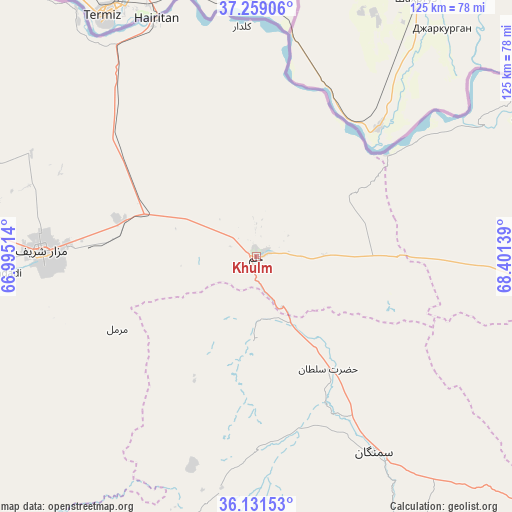
Khulm GPS coordinates[2]
36° 41' 50.496" North, 67° 41' 53.736" East
| Map corner | latitude | longitude |
|---|---|---|
| Upper-left | 37.25906°, | 66.99514° |
| Center: | 36.69736°, | 67.69826° |
| Lower-right: | 36.13153°, | 68.40139° |
| Map W x H: | 125.4×125.4 km | = 77.9×77.9mi |
| max Lat: | 38.4435° ⇑15.1% North |
| Khulm: | 36.69736° |
| min Lat: | ⇓84.9% South 30.15° |
| min Long | Khulm | max Long |
| 61.06667° | 67.69826° | 72.318° |
| W 43.1%⇐ | ⇒56.9% E |
Elevation
Elevation of Khulm is 445 m = 1460 ft, and this is 973.4 m = 3194 ft below average elevation for this country.
| Max E: |
3068 m = 10066 ft | 91% |
| Avg. | 1418.4 m = 4654 ft | |
| Khulm | 445 m = 1460 ft | |
Min E: |
254 m = 833 ft | 9% |
See also: Khulm elevation on elevation.city.
Geographical zone
Khulm is located in North temperate zone (between Tropic of Cancer and the Arctic Circle). Distance of this Northern Tropic circle is 1474.4 km =916.1 mi to South.| Distance of | km | miles | from Khulm |
|---|---|---|---|
| North Pole | 5926.7 | 3682.7 | to North |
| Arctic Circle | 3320.8 | 2063.4 | to North |
| Tropic Cancer | 1474.4 | 916.1 | to South |
| Equator | 4080.4 | 2535.4 | to South |


Nearby cities:
15 places around Khulm: (largest is in red/bold)
• Aliabad
109 km =67.7 mi,  100°
100°
• Aībak
55.8 km =34.7 mi,  149°
149°
• Balkh
71.7 km =44.6 mi,  275°
275°
• Chimtāl
79.8 km =49.6 mi,  268°
268°
• Dehdādī
63 km =39.1 mi, 266°
• Dehī
90.3 km =56.1 mi,  204°
204°
• Dowlatābād
84.5 km =52.5 mi,  292°
292°
• Dowr-e Rabāţ
97.4 km =60.5 mi,  90°
90°
• Kunduz
103.3 km =64.2 mi, 88°
• Lab-Sar
107.2 km =66.6 mi,  225°
225°
• Langar
84.3 km =52.4 mi,  157°
157°
• Mazār-e Sharīf
52.4 km =32.6 mi, 271°
• Qaranghū Tōghaī
57.8 km =35.9 mi,  354°
354°
• Qarchī Gak
89.4 km =55.6 mi,  295°
295°
• Āq Kupruk
102.7 km =63.8 mi, 228°
Sources, notices
• [Note1] Compared only with cities in Afghanistan existing in our database
• [Src1] Map data: © OpenStreetMap contributors (CC-BY-SA)
• [Src2] Other city data from geonames.org with taken over terms of usage.
• [Src3] Geographical zone / Annual Mean Temperature by Robert A. Rohde @ Wikipedia
