Dowlatābād geodata
Dowlatābād (Balkh) is a seat of a second-order administrative division; located in Afghanistan in Asia/Kabul (GMT+4.5) time zone. In our database, there are 93 cities with bigger population. Compared to other cities in Afghanistan, 91.3% of cities are located further ↓South; 63.3% of cities are located further →East and 96.5% of cities have higher elevation than Dowlatābād. Note1


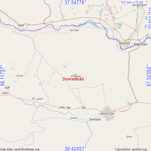
Dowlatābād GPS coordinates[2]
36° 59' 17.556" North, 66° 49' 14.484" East
| Map corner | latitude | longitude |
|---|---|---|
| Upper-left | 37.54776°, | 66.11757° |
| Center: | 36.98821°, | 66.82069° |
| Lower-right: | 36.42451°, | 67.52382° |
| Map W x H: | 124.9×124.9 km | = 77.6×77.6mi |
| max Lat: | 38.4435° ⇑8.7% North |
| Dowlatābād: | 36.98821° |
| min Lat: | ⇓91.3% South 30.15° |
| min Long | Dowlatābād | max Long |
| 61.06667° | 66.82069° | 72.318° |
| W 36.7%⇐ | ⇒63.3% E |
Elevation
Elevation of Dowlatābād is 312 m = 1024 ft, and this is 1106.4 m = 3630 ft below average elevation for this country.
| Max E: |
3068 m = 10066 ft | 96.5% |
| Avg. | 1418.4 m = 4654 ft | |
| Dowlatābād | 312 m = 1024 ft | |
Min E: |
254 m = 833 ft | 3.5% |
See also: Afghanistan elevation on elevation.city.
Geographical zone
Dowlatābād is located in North temperate zone (between Tropic of Cancer and the Arctic Circle). Distance of this Northern Tropic circle is 1506.8 km =936.3 mi to South.| Distance of | km | miles | from Dowlatābād |
|---|---|---|---|
| North Pole | 5894.4 | 3662.6 | to North |
| Arctic Circle | 3288.5 | 2043.4 | to North |
| Tropic Cancer | 1506.8 | 936.3 | to South |
| Equator | 4112.7 | 2555.5 | to South |


Nearby cities:
15 places around Dowlatābād: (largest is in red/bold)
• Balkh
26.7 km =16.6 mi,  165°
165°
• Chimtāl
34.5 km =21.4 mi,  182°
182°
• Dehdādī
39.3 km =24.4 mi,  156°
156°
• Faīẕābād
37.1 km =23.1 mi,  239°
239°
• Khulm
84.5 km =52.5 mi,  112°
112°
• Khānaqāh
59.8 km =37.2 mi,  256°
256°
• Mardīān
46.6 km =29 mi,  270°
270°
• Mazār-e Sharīf
40.4 km =25.1 mi,  140°
140°
• Mingajik
61.6 km =38.3 mi, 274°
• Qaranghū Tōghaī
76.9 km =47.8 mi,  70°
70°
• Qarchī Gak
6.4 km =4 mi,  333°
333°
• Qarqīn
83.8 km =52.1 mi,  304°
304°
• Shibirghān
101.5 km =63.1 mi,  249°
249°
• Āq Kupruk
100.6 km =62.5 mi, 179°
• Āqchah
57.4 km =35.7 mi, 260°
Sources, notices
• [Note1] Compared only with cities in Afghanistan existing in our database
• [Src1] Map data: © OpenStreetMap contributors (CC-BY-SA)
• [Src2] Other city data from geonames.org with taken over terms of usage.
• [Src3] Geographical zone / Annual Mean Temperature by Robert A. Rohde @ Wikipedia
