Dehdādī geodata
Dehdādī (Balkh) is a seat of a second-order administrative division; located in Afghanistan in Asia/Kabul (GMT+4.5) time zone. In our database, there are 93 cities with bigger population. Compared to other cities in Afghanistan, 83% of cities are located further ↓South; 61.4% of cities are located further →East and 92.6% of cities have higher elevation than Dehdādī. Note1


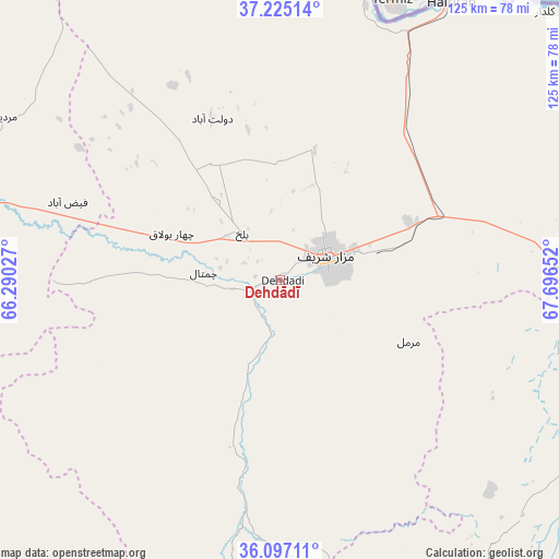
Dehdādī GPS coordinates[2]
36° 39' 47.484" North, 66° 59' 36.204" East
| Map corner | latitude | longitude |
|---|---|---|
| Upper-left | 37.22514°, | 66.29027° |
| Center: | 36.66319°, | 66.99339° |
| Lower-right: | 36.09711°, | 67.69652° |
| Map W x H: | 125.4×125.4 km | = 77.9×77.9mi |
| max Lat: | 38.4435° ⇑17% North |
| Dehdādī: | 36.66319° |
| min Lat: | ⇓83% South 30.15° |
| min Long | Dehdādī | max Long |
| 61.06667° | 66.99339° | 72.318° |
| W 38.6%⇐ | ⇒61.4% E |
Elevation
Elevation of Dehdādī is 398 m = 1306 ft, and this is 1020.4 m = 3348 ft below average elevation for this country.
| Max E: |
3068 m = 10066 ft | 92.6% |
| Avg. | 1418.4 m = 4654 ft | |
| Dehdādī | 398 m = 1306 ft | |
Min E: |
254 m = 833 ft | 7.4% |
See also: Afghanistan elevation on elevation.city.
Geographical zone
Dehdādī is located in North temperate zone (between Tropic of Cancer and the Arctic Circle). Distance of this Northern Tropic circle is 1470.6 km =913.8 mi to South.| Distance of | km | miles | from Dehdādī |
|---|---|---|---|
| North Pole | 5930.5 | 3685 | to North |
| Arctic Circle | 3324.6 | 2065.8 | to North |
| Tropic Cancer | 1470.6 | 913.8 | to South |
| Equator | 4076.6 | 2533.1 | to South |


Nearby cities:
15 places around Dehdādī: (largest is in red/bold)
• Balkh
13.4 km =8.3 mi,  320°
320°
• Chimtāl
17 km =10.6 mi,  275°
275°
• Dehī
82.5 km =51.3 mi,  161°
161°
• Dowlatābād
39.3 km =24.4 mi,  336°
336°
• Faīẕābād
50.7 km =31.5 mi,  290°
290°
• Khulm
63 km =39.1 mi,  86°
86°
• Khānaqāh
76.9 km =47.8 mi, 286°
• Lab-Sar
72.2 km =44.9 mi,  191°
191°
• Mardīān
72 km =44.7 mi,  300°
300°
• Mazār-e Sharīf
11.6 km =7.2 mi,  64°
64°
• Mingajik
87 km =54.1 mi, 297°
• Qaranghū Tōghaī
84.1 km =52.3 mi,  43°
43°
• Qarchī Gak
45.7 km =28.4 mi, 336°
• Āq Kupruk
65.9 km =40.9 mi, 192°
• Āqchah
77 km =47.8 mi, 290°
Sources, notices
• [Note1] Compared only with cities in Afghanistan existing in our database
• [Src1] Map data: © OpenStreetMap contributors (CC-BY-SA)
• [Src2] Other city data from geonames.org with taken over terms of usage.
• [Src3] Geographical zone / Annual Mean Temperature by Robert A. Rohde @ Wikipedia
