Injīl geodata
Injīl (Herat) is a seat of a second-order administrative division; located in Afghanistan in Asia/Kabul (GMT+4.5) time zone. In our database, there are 93 cities with bigger population. Compared to other cities in Afghanistan, 60.5% of cities are located further ↑North; 93.9% of cities are located further →East and 70.4% of cities have higher elevation than Injīl. Note1


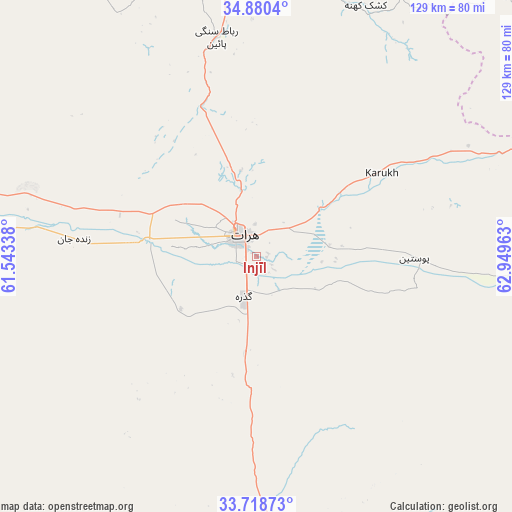
Injīl GPS coordinates[2]
34° 18' 5.652" North, 62° 14' 47.4" East
| Map corner | latitude | longitude |
|---|---|---|
| Upper-left | 34.8804°, | 61.54338° |
| Center: | 34.30157°, | 62.2465° |
| Lower-right: | 33.71873°, | 62.94963° |
| Map W x H: | 129.2×129.2 km | = 80.3×80.3mi |
| max Lat: | 38.4435° ⇑60.5% North |
| Injīl: | 34.30157° |
| min Lat: | ⇓39.5% South 30.15° |
| min Long | Injīl | max Long |
| 61.06667° | 62.2465° | 72.318° |
| W 6.1%⇐ | ⇒93.9% E |
Elevation
Elevation of Injīl is 937 m = 3074 ft, and this is 481.4 m = 1579 ft below average elevation for this country.
| Max E: |
3068 m = 10066 ft | 70.4% |
| Avg. | 1418.4 m = 4654 ft | |
| Injīl | 937 m = 3074 ft | |
Min E: |
254 m = 833 ft | 29.6% |
See also: Afghanistan elevation on elevation.city.
Geographical zone
Injīl is located in North temperate zone (between Tropic of Cancer and the Arctic Circle). Distance of this Northern Tropic circle is 1208.1 km =750.7 mi to South.| Distance of | km | miles | from Injīl |
|---|---|---|---|
| North Pole | 6193.1 | 3848.2 | to North |
| Arctic Circle | 3587.2 | 2229 | to North |
| Tropic Cancer | 1208.1 | 750.7 | to South |
| Equator | 3814 | 2369.9 | to South |


Nearby cities:
15 places around Injīl: (largest is in red/bold)
• Adraskan
73 km =45.4 mi,  178°
178°
• Chahār Burj
8.1 km =5 mi,  218°
218°
• Ghōriyān
69.3 km =43.1 mi,  273°
273°
• Guz̄arah
10.4 km =6.5 mi,  197°
197°
• Herāt
6.7 km =4.2 mi,  320°
320°
• Karukh
37 km =23 mi,  57°
57°
• Kuhsān
103.8 km =64.5 mi,  292°
292°
• Kushk-e Kuhnah
69.1 km =42.9 mi,  23°
23°
• Qala i Naw
111 km =69 mi,  46°
46°
• Qal‘ah-ye Fārsī
108.6 km =67.5 mi,  121°
121°
• Qarah Bāgh
83 km =51.6 mi,  328°
328°
• Qaryeh-ye Owbeh
85.7 km =53.3 mi,  84°
84°
• Rabāţ-e Sangī-ye Pā’īn
56.2 km =34.9 mi,  349°
349°
• Tīr Pul
95.4 km =59.3 mi, 289°
• Zindah Jān
46.1 km =28.6 mi,  275°
275°
Sources, notices
• [Note1] Compared only with cities in Afghanistan existing in our database
• [Src1] Map data: © OpenStreetMap contributors (CC-BY-SA)
• [Src2] Other city data from geonames.org with taken over terms of usage.
• [Src3] Geographical zone / Annual Mean Temperature by Robert A. Rohde @ Wikipedia
