Karukh geodata
Karukh (Herat) is a seat of a second-order administrative division; located in Afghanistan in Asia/Kabul (GMT+4.5) time zone. With population of 17,484 people, there are 38 cities with bigger population in this country. Compared to other cities in Afghanistan, 55.3% of cities are located further ↑North; 92.9% of cities are located further →East and 50.8% of cities have higher elevation than Karukh. Note1


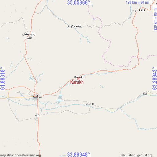
Karukh GPS coordinates[2]
34° 28' 51.888" North, 62° 35' 10.68" East
| Map corner | latitude | longitude |
|---|---|---|
| Upper-left | 35.05866°, | 61.88318° |
| Center: | 34.48108°, | 62.5863° |
| Lower-right: | 33.89948°, | 63.28943° |
| Map W x H: | 128.9×128.9 km | = 80.1×80.1mi |
| max Lat: | 38.4435° ⇑55.3% North |
| Karukh: | 34.48108° |
| min Lat: | ⇓44.7% South 30.15° |
| min Long | Karukh | max Long |
| 61.06667° | 62.5863° | 72.318° |
| W 7.1%⇐ | ⇒92.9% E |
Elevation
Elevation of Karukh is 1340 m = 4396 ft, and this is 78.4 m = 257 ft below average elevation for this country.
| Max E: |
3068 m = 10066 ft | 50.8% |
| Avg. | 1418.4 m = 4654 ft | |
| Karukh | 1340 m = 4396 ft | |
Min E: |
254 m = 833 ft | 49.2% |
See also: Afghanistan elevation on elevation.city.
Geographical zone
Karukh is located in North temperate zone (between Tropic of Cancer and the Arctic Circle). Distance of this Northern Tropic circle is 1228 km =763 mi to South.| Distance of | km | miles | from Karukh |
|---|---|---|---|
| North Pole | 6173.1 | 3835.8 | to North |
| Arctic Circle | 3567.2 | 2216.6 | to North |
| Tropic Cancer | 1228 | 763 | to South |
| Equator | 3833.9 | 2382.3 | to South |


Nearby cities:
15 places around Karukh: (largest is in red/bold)
• Adraskan
97.4 km =60.5 mi,  197°
197°
• Chahār Burj
44.8 km =27.8 mi,  234°
234°
• Guz̄arah
45.5 km =28.3 mi, 228°
• Herāt
38.4 km =23.9 mi,  247°
247°
• Injīl
37 km =23 mi,  237°
237°
• Kushk-e Kuhnah
43.5 km =27 mi,  355°
355°
• Qala i Naw
75 km =46.6 mi,  41°
41°
• Qal‘ah-ye Fārsī
98.4 km =61.1 mi,  141°
141°
• Qarah Bāgh
90 km =55.9 mi,  304°
304°
• Qaryeh-ye Owbeh
55.5 km =34.5 mi,  102°
102°
• Qādis
85.3 km =53 mi,  64°
64°
• Rabāţ-e Sangī-ye Pā’īn
54.1 km =33.6 mi,  310°
310°
• Sang Atesh
93.4 km =58 mi,  24°
24°
• Zindah Jān
78.5 km =48.8 mi,  258°
258°
• Āb-e Kamarī
80.5 km =50 mi,  33°
33°
Sources, notices
• [Note1] Compared only with cities in Afghanistan existing in our database
• [Src1] Map data: © OpenStreetMap contributors (CC-BY-SA)
• [Src2] Other city data from geonames.org with taken over terms of usage.
• [Src3] Geographical zone / Annual Mean Temperature by Robert A. Rohde @ Wikipedia
