Qaryeh-ye Owbeh geodata
Qaryeh-ye Owbeh (Herat) is a seat of a second-order administrative division; located in Afghanistan in Asia/Kabul (GMT+4.5) time zone. In our database, there are 93 cities with bigger population. Compared to other cities in Afghanistan, 57.9% of cities are located further ↑North; 90.7% of cities are located further →East and 52.7% of cities have higher elevation than Qaryeh-ye Owbeh. Note1


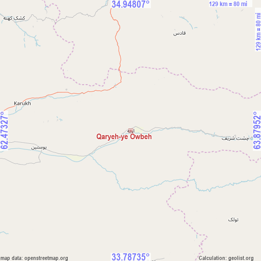
Qaryeh-ye Owbeh GPS coordinates[2]
34° 22' 10.992" North, 63° 10' 35.004" East
| Map corner | latitude | longitude |
|---|---|---|
| Upper-left | 34.94807°, | 62.47327° |
| Center: | 34.36972°, | 63.17639° |
| Lower-right: | 33.78735°, | 63.87952° |
| Map W x H: | 129.1×129.1 km | = 80.2×80.2mi |
| max Lat: | 38.4435° ⇑57.9% North |
| Qaryeh-ye Owbeh: | 34.36972° |
| min Lat: | ⇓42.1% South 30.15° |
| min Long | Qaryeh-ye Owbeh | max Long |
| 61.06667° | 63.17639° | 72.318° |
| W 9.3%⇐ | ⇒90.7% E |
Elevation
Elevation of Qaryeh-ye Owbeh is 1287 m = 4222 ft, and this is 131.4 m = 431 ft below average elevation for this country.
| Max E: |
3068 m = 10066 ft | 52.7% |
| Avg. | 1418.4 m = 4654 ft | |
| Qaryeh-ye Owbeh | 1287 m = 4222 ft | |
Min E: |
254 m = 833 ft | 47.3% |
See also: Afghanistan elevation on elevation.city.
Geographical zone
Qaryeh-ye Owbeh is located in North temperate zone (between Tropic of Cancer and the Arctic Circle). Distance of this Northern Tropic circle is 1215.6 km =755.3 mi to South.| Distance of | km | miles | from Qaryeh-ye Owbeh |
|---|---|---|---|
| North Pole | 6185.5 | 3843.5 | to North |
| Arctic Circle | 3579.6 | 2224.3 | to North |
| Tropic Cancer | 1215.6 | 755.3 | to South |
| Equator | 3821.6 | 2374.6 | to South |


Nearby cities:
15 places around Qaryeh-ye Owbeh: (largest is in red/bold)
• Chahār Burj
91.5 km =56.9 mi,  261°
261°
• Chisht-e Sharīf
51.8 km =32.2 mi,  92°
92°
• Guz̄arah
90.3 km =56.1 mi, 258°
• Herāt
89.7 km =55.7 mi,  268°
268°
• Injīl
85.7 km =53.3 mi, 264°
• Karukh
55.5 km =34.5 mi,  282°
282°
• Kushk-e Kuhnah
80.1 km =49.8 mi,  314°
314°
• Qala i Naw
68.8 km =42.8 mi,  356°
356°
• Qal‘ah-ye Fārsī
65.3 km =40.6 mi,  174°
174°
• Qādis
54 km =33.6 mi,  25°
25°
• Rabāţ-e Sangī-ye Pā’īn
106.3 km =66.1 mi,  296°
296°
• Sang Atesh
98.9 km =61.5 mi,  350°
350°
• Tītān
98.6 km =61.3 mi,  140°
140°
• Tūlak
67.1 km =41.7 mi,  130°
130°
• Āb-e Kamarī
80.5 km =50 mi, 352°
Sources, notices
• [Note1] Compared only with cities in Afghanistan existing in our database
• [Src1] Map data: © OpenStreetMap contributors (CC-BY-SA)
• [Src2] Other city data from geonames.org with taken over terms of usage.
• [Src3] Geographical zone / Annual Mean Temperature by Robert A. Rohde @ Wikipedia
