Qarqīn geodata
Qarqīn (Jowzjan) is a seat of a second-order administrative division; located in Afghanistan in Asia/Kabul (GMT+4.5) time zone. With population of 15,018 people, there are 47 cities with bigger population in this country. Compared to other cities in Afghanistan, 97.1% of cities are located further ↓South; 71.7% of cities are located further →East and 99.7% of cities have higher elevation than Qarqīn. Note1


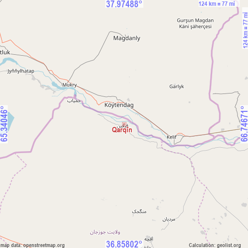
Qarqīn GPS coordinates[2]
37° 25' 6.708" North, 66° 2' 36.888" East
| Map corner | latitude | longitude |
|---|---|---|
| Upper-left | 37.97488°, | 65.34046° |
| Center: | 37.41853°, | 66.04358° |
| Lower-right: | 36.85802°, | 66.74671° |
| Map W x H: | 124.2×124.2 km | = 77.2×77.2mi |
| max Lat: | 38.4435° ⇑2.9% North |
| Qarqīn: | 37.41853° |
| min Lat: | ⇓97.1% South 30.15° |
| min Long | Qarqīn | max Long |
| 61.06667° | 66.04358° | 72.318° |
| W 28.3%⇐ | ⇒71.7% E |
Elevation
Elevation of Qarqīn is 263 m = 863 ft, and this is 1155.4 m = 3791 ft below average elevation for this country.
| Max E: |
3068 m = 10066 ft | 99.7% |
| Avg. | 1418.4 m = 4654 ft | |
| Qarqīn | 263 m = 863 ft | |
Min E: |
254 m = 833 ft | 0.3% |
See also: Afghanistan elevation on elevation.city.
Geographical zone
Qarqīn is located in North temperate zone (between Tropic of Cancer and the Arctic Circle). Distance of this Northern Tropic circle is 1554.6 km =966 mi to South.| Distance of | km | miles | from Qarqīn |
|---|---|---|---|
| North Pole | 5846.5 | 3632.8 | to North |
| Arctic Circle | 3240.6 | 2013.6 | to North |
| Tropic Cancer | 1554.6 | 966 | to South |
| Equator | 4160.6 | 2585.3 | to South |


Nearby cities:
15 places around Qarqīn: (largest is in red/bold)
• Andkhōy
96.5 km =60 mi,  237°
237°
• Balkh
105.6 km =65.6 mi,  134°
134°
• Chahār Bāgh
86.2 km =53.6 mi, 237°
• Chimtāl
106.4 km =66.1 mi,  140°
140°
• Dowlatābād
83.8 km =52.1 mi,  124°
124°
• Faīẕābād
76 km =47.2 mi,  150°
150°
• Khamyāb
27.9 km =17.3 mi,  295°
295°
• Khwājah Dū Kōh
75.4 km =46.9 mi,  209°
209°
• Khānaqāh
62.7 km =39 mi,  169°
169°
• Mardīān
52.4 km =32.6 mi, 154°
• Mingajik
44.1 km =27.4 mi, 170°
• Qarchī Gak
78.3 km =48.7 mi, 122°
• Qurghān
103 km =64 mi, 237°
• Shibirghān
87.4 km =54.3 mi,  197°
197°
• Āqchah
58.4 km =36.3 mi, 167°
Sources, notices
• [Note1] Compared only with cities in Afghanistan existing in our database
• [Src1] Map data: © OpenStreetMap contributors (CC-BY-SA)
• [Src2] Other city data from geonames.org with taken over terms of usage.
• [Src3] Geographical zone / Annual Mean Temperature by Robert A. Rohde @ Wikipedia
