Nhill geodata
Nhill (Victoria) is a populated place; located in Australia in Australia/Melbourne (GMT+11) time zone. With population of 2,156 people, there are 2791 cities with bigger population in this country. Compared to other cities in Australia, 79.5% of cities are located further ↑North; 75.2% of cities are located further →East and 75.1% of cities have lower elevation than Nhill. Note1


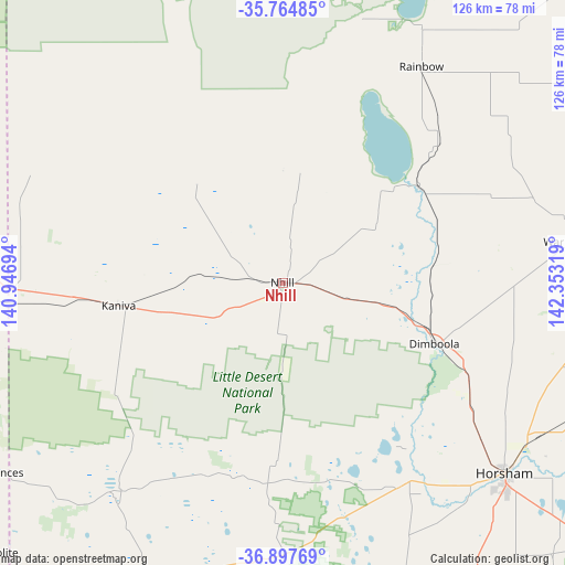
Nhill GPS coordinates[2]
36° 19' 59.988" South, 141° 39' 0.216" East
| Map corner | latitude | longitude |
|---|---|---|
| Upper-left | -35.76485°, | 140.94694° |
| Center: | -36.33333°, | 141.65006° |
| Lower-right: | -36.89769°, | 142.35319° |
| Map W x H: | 126×126 km | = 78.3×78.3mi |
| max Lat: | -10.58257° ⇑79.5% North |
| Nhill: | -36.33333° |
| min Lat: | ⇓20.5% South -43.31423° |
| min Long | Nhill | max Long |
| 113.53327° | 141.65006° | 153.61246° |
| W 24.8%⇐ | ⇒75.2% E |
Elevation
Elevation of Nhill is 132 m = 433 ft, and this is 10 m = 33 ft above average elevation for this country.
| Max E: |
1715 m = 5627 ft | 24.9% |
| Nhill | 132 m 433 ft | |
| Avg. | 122 m = 400 ft | |
Min E: |
-2 m = -7 ft | 75.1% |
See also: Australia elevation on elevation.city.
Geographical zone
Nhill is located in South temperate zone (between Tropic of Capricorn and the Antarctic Circle). Distance of this Southern Tropic circle is 1434 km =891 mi to North.| Distance of | km | miles | from Nhill |
|---|---|---|---|
| Equator | 4039.9 | 2510.3 | to North |
| Tropic Capricorn | 1434 | 891 | to North |
| Antarctic Circle | 3361.3 | 2088.6 | to South |
| South Pole | 5967.2 | 3707.8 | to South |


Nearby cities:
15 places around Nhill: (largest is in red/bold)
• Bordertown
78.7 km =48.9 mi,  272°
272°
• Dimboola
36.9 km =22.9 mi,  111°
111°
• Donald
119.3 km =74.1 mi,  91°
91°
• Edenhope
84.3 km =52.4 mi,  201°
201°
• Halls Gap
119.3 km =74.1 mi,  139°
139°
• Haven
68 km =42.3 mi,  134°
134°
• Hopetoun
93.2 km =57.9 mi,  43°
43°
• Horsham
64.6 km =40.1 mi, 130°
• Kaniva
36.9 km =22.9 mi,  262°
262°
• Keith
119.2 km =74.1 mi,  282°
282°
• Murtoa
79.7 km =49.5 mi, 113°
• Naracoorte
106.9 km =66.4 mi,  229°
229°
• Rainbow
57.8 km =35.9 mi,  32°
32°
• Rupanyup
93.7 km =58.2 mi, 110°
• Warracknabeal
67.2 km =41.8 mi,  82°
82°
Sources, notices
• [Note1] Compared only with cities in Australia existing in our database
• [Src1] Map data: © OpenStreetMap contributors (CC-BY-SA)
• [Src2] Other city data from geonames.org with taken over terms of usage.
• [Src3] Geographical zone / Annual Mean Temperature by Robert A. Rohde @ Wikipedia
