Samur geodata
Samur (Qusar) is a populated place; located in Azerbaijan in Asia/Baku (GMT+4) time zone. With population of 1,760 people, there are 153 cities with bigger population in this country. Compared to other cities in Azerbaijan, 98.9% of cities are located further ↓South; 60.5% of cities are located further ←West and 57.3% of cities have lower elevation than Samur. Note1


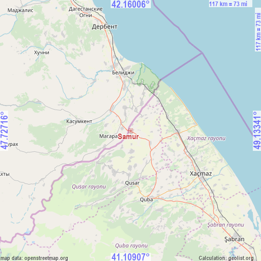
Samur GPS coordinates[2]
41° 38' 12.156" North, 48° 25' 49.008" East
| Map corner | latitude | longitude |
|---|---|---|
| Upper-left | 42.16006°, | 47.72716° |
| Center: | 41.63671°, | 48.43028° |
| Lower-right: | 41.10907°, | 49.13341° |
| Map W x H: | 116.9×116.9 km | = 72.6×72.6mi |
| max Lat: | 41.75259° ⇑1.1% North |
| Samur: | 41.63671° |
| min Lat: | ⇓98.9% South 38.45598° |
| min Long | Samur | max Long |
| 44.84846° | 48.43028° | 50.84003° |
| W 60.5%⇐ | ⇒39.5% E |
Elevation
Elevation of Samur is 307 m = 1007 ft, and this is 76 m = 249 ft below average elevation for this country.
| Max E: |
2211 m = 7254 ft | 42.7% |
| Avg. | 383 m = 1257 ft | |
| Samur | 307 m = 1007 ft | |
Min E: |
-26 m = -85 ft | 57.3% |
See also: Azerbaijan elevation on elevation.city.
Geographical zone
Samur is located in North temperate zone (between Tropic of Cancer and the Arctic Circle). Distance of this Northern Tropic circle is 2023.6 km =1257.4 mi to South.| Distance of | km | miles | from Samur |
|---|---|---|---|
| North Pole | 5377.5 | 3341.4 | to North |
| Arctic Circle | 2771.6 | 1722.2 | to North |
| Tropic Cancer | 2023.6 | 1257.4 | to South |
| Equator | 4629.6 | 2876.7 | to South |


Nearby cities:
15 places around Samur: (largest is in red/bold)
• Altıağac
96.3 km =59.8 mi,  154°
154°
• Basqal
98.1 km =61 mi,  181°
181°
• Divichibazar
67.1 km =41.7 mi,  136°
136°
• Gilgilçay
78 km =48.5 mi, 135°
• Hacıhüseynli
27.1 km =16.8 mi, 137°
• Khyzy
97.2 km =60.4 mi, 146°
• Kyzyl-Burun
84.4 km =52.4 mi, 137°
• Lahıc
88 km =54.7 mi, 182°
• Oğuz
102.2 km =63.5 mi,  232°
232°
• Quba
31.4 km =19.5 mi,  167°
167°
• Qusar
23.3 km =14.5 mi, 180°
• Qutqashen
87.5 km =54.4 mi,  213°
213°
• Xaçmaz
36.7 km =22.8 mi,  121°
121°
• Xudat
20.9 km =13 mi,  91°
91°
• İsmayıllı
97.5 km =60.6 mi,  193°
193°
Sources, notices
• [Note1] Compared only with cities in Azerbaijan existing in our database
• [Src1] Map data: © OpenStreetMap contributors (CC-BY-SA)
• [Src2] Other city data from geonames.org with taken over terms of usage.
• [Src3] Geographical zone / Annual Mean Temperature by Robert A. Rohde @ Wikipedia
