Jakar geodata
Jakar (Bumthang) is a seat of a first-order administrative division; located in Bhutan in Asia/Thimphu (GMT+6) time zone. With population of 4,829 people, there are 9 cities with bigger population in this country. Compared to other cities in Bhutan, 85.2% of cities are located further ↓South; 63% of cities are located further ←West and 92.6% of cities have lower elevation than Jakar. Note1


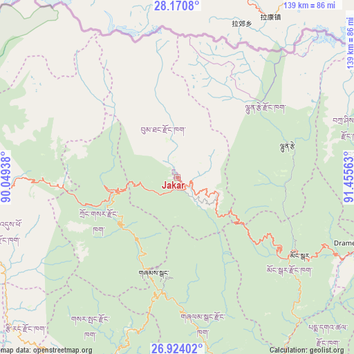
Jakar GPS coordinates[2]
27° 32' 57.048" North, 90° 45' 9" East
| Map corner | latitude | longitude |
|---|---|---|
| Upper-left | 28.1708°, | 90.04938° |
| Center: | 27.54918°, | 90.7525° |
| Lower-right: | 26.92402°, | 91.45563° |
| Map W x H: | 138.6×138.6 km | = 86.1×86.1mi |
| max Lat: | 27.90372° ⇑14.8% North |
| Jakar: | 27.54918° |
| min Lat: | ⇓85.2% South 26.78333° |
| min Long | Jakar | max Long |
| 89.09951° | 90.7525° | 92.1° |
| W 63%⇐ | ⇒37% E |
Elevation
Elevation of Jakar is 2587 m = 8488 ft, and this is 1208.8 m = 3966 ft above average elevation for this country.
| Max E: |
2761 m = 9058 ft | 7.4% |
| Jakar | 2587 m 8488 ft | |
| Avg. | 1378.2 m = 4522 ft | |
Min E: |
145 m = 476 ft | 92.6% |
See also: Bhutan elevation on elevation.city.
Geographical zone
Jakar is located in North temperate zone (between Tropic of Cancer and the Arctic Circle). Distance of this Northern Tropic circle is 457.3 km =284.2 mi to South.| Distance of | km | miles | from Jakar |
|---|---|---|---|
| North Pole | 6943.9 | 4314.7 | to North |
| Arctic Circle | 4338 | 2695.5 | to North |
| Tropic Cancer | 457.3 | 284.2 | to South |
| Equator | 3063.2 | 1903.4 | to South |


Nearby cities:
15 places around Jakar: (largest is in red/bold)
• Daga
101.3 km =62.9 mi,  238°
238°
• Lhuentse
44.5 km =27.7 mi,  72°
72°
• Mongar
56.9 km =35.4 mi,  122°
122°
• Nganglam
98.4 km =61.1 mi,  149°
149°
• Pajo
85.7 km =53.3 mi,  268°
268°
• Panbang
79.2 km =49.2 mi,  163°
163°
• Pemagatshel
85.8 km =53.3 mi,  131°
131°
• Punākha
86.4 km =53.7 mi, 273°
• Sarpang
90 km =55.9 mi,  212°
212°
• Shemgang
38.1 km =23.7 mi,  194°
194°
• Trashi Yangtse
73.8 km =45.9 mi,  84°
84°
• Trashigang
82.7 km =51.4 mi,  106°
106°
• Trongsa
24.7 km =15.3 mi,  257°
257°
• Tsirang
85.5 km =53.1 mi,  226°
226°
• Wangdue Phodrang
84.4 km =52.4 mi, 265°
Sources, notices
• [Note1] Compared only with cities in Bhutan existing in our database
• [Src1] Map data: © OpenStreetMap contributors (CC-BY-SA)
• [Src2] Other city data from geonames.org with taken over terms of usage.
• [Src3] Geographical zone / Annual Mean Temperature by Robert A. Rohde @ Wikipedia
