Sebina geodata
Sebina (North-East) is a populated place; located in Botswana in Africa/Gaborone (GMT+2) time zone. With population of 3,030 people, there are 44 cities with bigger population in this country. Compared to other cities in Botswana, 83.8% of cities are located further ↓South; 77.1% of cities are located further ←West and 68.6% of cities have lower elevation than Sebina. Note1


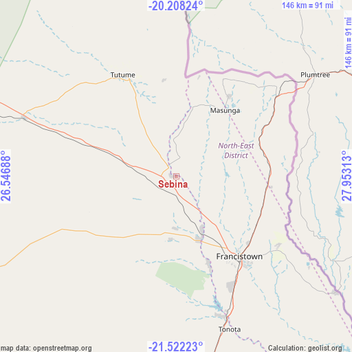
Sebina GPS coordinates[2]
20° 52' 0.012" South, 27° 15' 0" East
| Map corner | latitude | longitude |
|---|---|---|
| Upper-left | -20.20824°, | 26.54688° |
| Center: | -20.86667°, | 27.25° |
| Lower-right: | -21.52223°, | 27.95313° |
| Map W x H: | 146.1×146.1 km | = 90.8×90.8mi |
| max Lat: | -17.80165° ⇑16.2% North |
| Sebina: | -20.86667° |
| min Lat: | ⇓83.8% South -26.9° |
| min Long | Sebina | max Long |
| 20.06667° | 27.25° | 28.74946° |
| W 77.1%⇐ | ⇒22.9% E |
Elevation
Elevation of Sebina is 1071 m = 3514 ft, and this is 56 m = 184 ft above average elevation for this country.
| Max E: |
1406 m = 4613 ft | 31.4% |
| Sebina | 1071 m 3514 ft | |
| Avg. | 1015 m = 3330 ft | |
Min E: |
676 m = 2218 ft | 68.6% |
See also: Botswana elevation on elevation.city.
Geographical zone
Sebina is located in South Torrid zone (between Equator and Tropic of Capricorn). Distance of this Southern Tropic circle is 285.8 km =177.6 mi to South.| Distance of | km | miles | from Sebina |
|---|---|---|---|
| Equator | 2320.2 | 1441.7 | to North |
| Tropic Capricorn | 285.8 | 177.6 | to South |
| Antarctic Circle | 5081 | 3157.2 | to South |
| South Pole | 7686.9 | 4776.4 | to South |


Nearby cities:
15 places around Sebina: (largest is in red/bold)
• Dukwe
92.2 km =57.3 mi,  289°
289°
• Francistown
43.1 km =26.8 mi,  141°
141°
• Kalakamati
31.1 km =19.3 mi,  11°
11°
• Makaleng
5.1 km =3.2 mi, 136°
• Masunga
33.9 km =21.1 mi,  37°
37°
• Mathambgwane
16.2 km =10.1 mi,  148°
148°
• Mogapi
172.9 km =107.4 mi,  159°
159°
• Mogapinyana
170.7 km =106.1 mi,  167°
167°
• Mosetse
63.7 km =39.6 mi,  281°
281°
• Nata
132.5 km =82.3 mi,  303°
303°
• Sefophe
164.1 km =102 mi, 153°
• Selebi-Phikwe
138.1 km =85.8 mi, 153°
• Sua
142.2 km =88.4 mi,  309°
309°
• Tobane
138 km =85.7 mi, 150°
• Tonota
67.7 km =42.1 mi, 161°
Sources, notices
• [Note1] Compared only with cities in Botswana existing in our database
• [Src1] Map data: © OpenStreetMap contributors (CC-BY-SA)
• [Src2] Other city data from geonames.org with taken over terms of usage.
• [Src3] Geographical zone / Annual Mean Temperature by Robert A. Rohde @ Wikipedia
