Mathambgwane geodata
Mathambgwane (Central) is a populated place; located in Botswana in Africa/Gaborone (GMT+2) time zone. With population of 4,675 people, there are 33 cities with bigger population in this country. Compared to other cities in Botswana, 81.9% of cities are located further ↓South; 82.9% of cities are located further ←West and 62.9% of cities have lower elevation than Mathambgwane. Note1


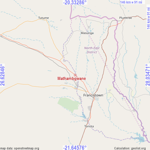
Mathambgwane GPS coordinates[2]
20° 59' 26.7" South, 27° 19' 53.688" East
| Map corner | latitude | longitude |
|---|---|---|
| Upper-left | -20.33286°, | 26.62846° |
| Center: | -20.99075°, | 27.33158° |
| Lower-right: | -21.64576°, | 28.03471° |
| Map W x H: | 146×146 km | = 90.7×90.7mi |
| max Lat: | -17.80165° ⇑18.1% North |
| Mathambgwane: | -20.99075° |
| min Lat: | ⇓81.9% South -26.9° |
| min Long | Mathambgwane | max Long |
| 20.06667° | 27.33158° | 28.74946° |
| W 82.9%⇐ | ⇒17.1% E |
Elevation
Elevation of Mathambgwane is 1048 m = 3438 ft, and this is 33 m = 108 ft above average elevation for this country.
| Max E: |
1406 m = 4613 ft | 37.1% |
| Mathambgwane | 1048 m 3438 ft | |
| Avg. | 1015 m = 3330 ft | |
Min E: |
676 m = 2218 ft | 62.9% |
See also: Botswana elevation on elevation.city.
Geographical zone
Mathambgwane is located in South Torrid zone (between Equator and Tropic of Capricorn). Distance of this Southern Tropic circle is 272 km =169 mi to South.| Distance of | km | miles | from Mathambgwane |
|---|---|---|---|
| Equator | 2334 | 1450.3 | to North |
| Tropic Capricorn | 272 | 169 | to South |
| Antarctic Circle | 5067.2 | 3148.6 | to South |
| South Pole | 7673.1 | 4767.8 | to South |


Nearby cities:
15 places around Mathambgwane: (largest is in red/bold)
• Dukwe
105.3 km =65.4 mi,  295°
295°
• Francistown
27 km =16.8 mi,  137°
137°
• Kalakamati
44.4 km =27.6 mi,  357°
357°
• Makaleng
11.3 km =7 mi,  333°
333°
• Masunga
42.5 km =26.4 mi,  16°
16°
• Mogapi
157 km =97.6 mi,  160°
160°
• Mogapinyana
155.5 km =96.6 mi,  169°
169°
• Mosetse
75.7 km =47 mi,  290°
290°
• Nata
147.3 km =91.5 mi,  305°
305°
• Sebina
16.2 km =10.1 mi, 328°
• Sefophe
148 km =92 mi,  153°
153°
• Selebi-Phikwe
122 km =75.8 mi, 154°
• Sua
157.6 km =97.9 mi, 311°
• Tobane
121.8 km =75.7 mi, 151°
• Tonota
52 km =32.3 mi, 164°
Sources, notices
• [Note1] Compared only with cities in Botswana existing in our database
• [Src1] Map data: © OpenStreetMap contributors (CC-BY-SA)
• [Src2] Other city data from geonames.org with taken over terms of usage.
• [Src3] Geographical zone / Annual Mean Temperature by Robert A. Rohde @ Wikipedia
