Kalakamati geodata
Kalakamati (North-East) is a populated place; located in Botswana in Africa/Gaborone (GMT+2) time zone. With population of 962 people, there are 87 cities with bigger population in this country. Compared to other cities in Botswana, 86.7% of cities are located further ↓South; 81% of cities are located further ←West and 89.5% of cities have lower elevation than Kalakamati. Note1


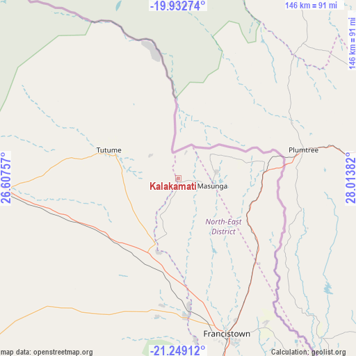
Kalakamati GPS coordinates[2]
20° 35' 32.46" South, 27° 18' 38.484" East
| Map corner | latitude | longitude |
|---|---|---|
| Upper-left | -19.93274°, | 26.60757° |
| Center: | -20.59235°, | 27.31069° |
| Lower-right: | -21.24912°, | 28.01382° |
| Map W x H: | 146.4×146.4 km | = 91×91mi |
| max Lat: | -17.80165° ⇑13.3% North |
| Kalakamati: | -20.59235° |
| min Lat: | ⇓86.7% South -26.9° |
| min Long | Kalakamati | max Long |
| 20.06667° | 27.31069° | 28.74946° |
| W 81%⇐ | ⇒19% E |
Elevation
Elevation of Kalakamati is 1180 m = 3871 ft, and this is 165 m = 541 ft above average elevation for this country.
| Max E: |
1406 m = 4613 ft | 10.5% |
| Kalakamati | 1180 m 3871 ft | |
| Avg. | 1015 m = 3330 ft | |
Min E: |
676 m = 2218 ft | 89.5% |
See also: Botswana elevation on elevation.city.
Geographical zone
Kalakamati is located in South Torrid zone (between Equator and Tropic of Capricorn). Distance of this Southern Tropic circle is 316.3 km =196.5 mi to South.| Distance of | km | miles | from Kalakamati |
|---|---|---|---|
| Equator | 2289.7 | 1422.8 | to North |
| Tropic Capricorn | 316.3 | 196.5 | to South |
| Antarctic Circle | 5111.5 | 3176.1 | to South |
| South Pole | 7717.4 | 4795.4 | to South |


Nearby cities:
15 places around Kalakamati: (largest is in red/bold)
• Dukwe
93.1 km =57.8 mi,  270°
270°
• Francistown
67.4 km =41.9 mi,  162°
162°
• Makaleng
34.3 km =21.3 mi,  184°
184°
• Masunga
14.8 km =9.2 mi,  103°
103°
• Mathambgwane
44.4 km =27.6 mi, 177°
• Mogapi
199.9 km =124.2 mi, 164°
• Mogapinyana
199.5 km =124 mi,  171°
171°
• Mosetse
70.9 km =44.1 mi,  255°
255°
• Nata
124.7 km =77.5 mi,  289°
289°
• Sebina
31.1 km =19.3 mi,  191°
191°
• Sefophe
189.5 km =117.7 mi, 158°
• Selebi-Phikwe
163.7 km =101.7 mi, 160°
• Sua
130.6 km =81.2 mi,  297°
297°
• Tobane
162.8 km =101.2 mi, 157°
• Tonota
95.8 km =59.5 mi, 170°
Sources, notices
• [Note1] Compared only with cities in Botswana existing in our database
• [Src1] Map data: © OpenStreetMap contributors (CC-BY-SA)
• [Src2] Other city data from geonames.org with taken over terms of usage.
• [Src3] Geographical zone / Annual Mean Temperature by Robert A. Rohde @ Wikipedia
