Gamboula geodata
Gamboula (Mambéré-Kadéï) is a populated place; located in Central African Republic in Africa/Bangui (GMT+1) time zone. With population of 7,646 people, there are 29 cities with bigger population in this country. Compared to other cities in Central African Republic, 91.4% of cities are located further ↑North; 100% of cities are located further →East and 77.1% of cities have lower elevation than Gamboula. Note1


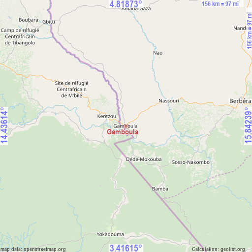
Gamboula GPS coordinates[2]
4° 7' 3.9" North, 15° 8' 21.336" East
| Map corner | latitude | longitude |
|---|---|---|
| Upper-left | 4.81873°, | 14.43614° |
| Center: | 4.11775°, | 15.13926° |
| Lower-right: | 3.41615°, | 15.84239° |
| Map W x H: | 156×156 km | = 96.9×96.9mi |
| max Lat: | 10.28488° ⇑91.4% North |
| Gamboula: | 4.11775° |
| min Lat: | ⇓8.6% South 3.52494° |
| min Long | Gamboula | max Long |
| 15.13926° | 15.13926° | 26.49211° |
| W 0%⇐ | ⇒100% E |
Elevation
Elevation of Gamboula is 589 m = 1932 ft, and this is 83.7 m = 275 ft above average elevation for this country.
| Max E: |
976 m = 3202 ft | 22.9% |
| Gamboula | 589 m 1932 ft | |
| Avg. | 505.3 m = 1658 ft | |
Min E: |
351 m = 1152 ft | 77.1% |
See also: Central African Republic elevation on elevation.city.
Geographical zone
Gamboula is located in North Torrid zone (between Equator and Tropic of Cancer). Distance of Equator is 457.9 km =284.5 mi to South.| Distance of | km | miles | from Gamboula |
|---|---|---|---|
| North Pole | 9549.2 | 5933.6 | to North |
| Arctic Circle | 6943.3 | 4314.4 | to North |
| Tropic Cancer | 2148.1 | 1334.8 | to North |
| Equator | 457.9 | 284.5 | to South |


Nearby cities:
15 places around Gamboula: (largest is in red/bold)
• Bangui
379.7 km =235.9 mi,  85°
85°
• Baoro
195.1 km =121.2 mi,  28°
28°
• Berbérati
74.1 km =46 mi,  77°
77°
• Bimbo
363.7 km =226 mi, 87°
• Boali
339.8 km =211.1 mi, 77°
• Boda
259.4 km =161.2 mi, 85°
• Bossangoa
368.1 km =228.7 mi,  44°
44°
• Bouar
208.2 km =129.4 mi,  14°
14°
• Bozoum
280.7 km =174.4 mi, 29°
• Carnot
122.9 km =76.4 mi, 41°
• Damara
406 km =252.3 mi, 76°
• Mbaïki
317.3 km =197.2 mi,  95°
95°
• Mongoumba
386.9 km =240.4 mi, 97°
• Nola
120.3 km =74.8 mi,  123°
123°
• Paoua
376.1 km =233.7 mi,  22°
22°
Sources, notices
• [Note1] Compared only with cities in Central African Republic existing in our database
• [Src1] Map data: © OpenStreetMap contributors (CC-BY-SA)
• [Src2] Other city data from geonames.org with taken over terms of usage.
• [Src3] Geographical zone / Annual Mean Temperature by Robert A. Rohde @ Wikipedia
