Baoro geodata
Baoro (Nana-Mambéré) is a populated place; located in Central African Republic in Africa/Bangui (GMT+1) time zone. With population of 6,319 people, there are 31 cities with bigger population in this country. Compared to other cities in Central African Republic, 57.1% of cities are located further ↓South; 88.6% of cities are located further →East and 97.1% of cities have lower elevation than Baoro. Note1


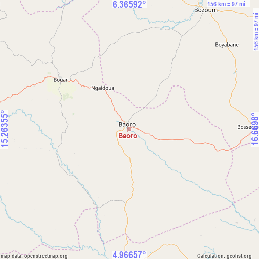
Baoro GPS coordinates[2]
5° 40' 0.012" North, 15° 58' 0.012" East
| Map corner | latitude | longitude |
|---|---|---|
| Upper-left | 6.36592°, | 15.26355° |
| Center: | 5.66667°, | 15.96667° |
| Lower-right: | 4.96657°, | 16.6698° |
| Map W x H: | 155.6×155.6 km | = 96.7×96.7mi |
| max Lat: | 10.28488° ⇑42.9% North |
| Baoro: | 5.66667° |
| min Lat: | ⇓57.1% South 3.52494° |
| min Long | Baoro | max Long |
| 15.13926° | 15.96667° | 26.49211° |
| W 11.4%⇐ | ⇒88.6% E |
Elevation
Elevation of Baoro is 728 m = 2388 ft, and this is 222.7 m = 731 ft above average elevation for this country.
| Max E: |
976 m = 3202 ft | 2.9% |
| Baoro | 728 m 2388 ft | |
| Avg. | 505.3 m = 1658 ft | |
Min E: |
351 m = 1152 ft | 97.1% |
See also: Central African Republic elevation on elevation.city.
Geographical zone
Baoro is located in North Torrid zone (between Equator and Tropic of Cancer). Distance of Equator is 630.1 km =391.5 mi to South.| Distance of | km | miles | from Baoro |
|---|---|---|---|
| North Pole | 9377 | 5826.6 | to North |
| Arctic Circle | 6771.1 | 4207.4 | to North |
| Tropic Cancer | 1975.8 | 1227.7 | to North |
| Equator | 630.1 | 391.5 | to South |


Nearby cities:
15 places around Baoro: (largest is in red/bold)
• Batangafo
313.9 km =195 mi,  54°
54°
• Berbérati
157.5 km =97.9 mi,  187°
187°
• Bimbo
313.3 km =194.7 mi,  120°
120°
• Boali
257.9 km =160.3 mi,  111°
111°
• Boda
224 km =139.2 mi,  131°
131°
• Bossangoa
188.5 km =117.1 mi,  60°
60°
• Bouar
50.6 km =31.4 mi,  305°
305°
• Bouca
272 km =169 mi,  69°
69°
• Bozoum
85.8 km =53.3 mi,  32°
32°
• Carnot
81.1 km =50.4 mi, 187°
• Damara
313 km =194.5 mi,  104°
104°
• Gamboula
195.1 km =121.2 mi,  208°
208°
• Mbaïki
300.4 km =186.7 mi, 131°
• Nola
238.3 km =148.1 mi,  177°
177°
• Paoua
182.9 km =113.6 mi,  16°
16°
Sources, notices
• [Note1] Compared only with cities in Central African Republic existing in our database
• [Src1] Map data: © OpenStreetMap contributors (CC-BY-SA)
• [Src2] Other city data from geonames.org with taken over terms of usage.
• [Src3] Geographical zone / Annual Mean Temperature by Robert A. Rohde @ Wikipedia
