Ewo geodata
Ewo (Cuvette-Ouest) is a seat of a first-order administrative division; located in Republic of the Congo in Africa/Brazzaville (GMT+1) time zone. With population of 4,923 people, there are 15 cities with bigger population in this country. Compared to other cities in Republic of the Congo, 73.7% of cities are located further ↓South; 63.2% of cities are located further ←West and 68.4% of cities have lower elevation than Ewo. Note1


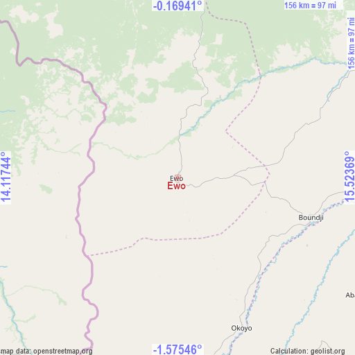
Ewo GPS coordinates[2]
0° 52' 21" South, 14° 49' 14.016" East
| Map corner | latitude | longitude |
|---|---|---|
| Upper-left | -0.16941°, | 14.11744° |
| Center: | -0.8725°, | 14.82056° |
| Lower-right: | -1.57546°, | 15.52369° |
| Map W x H: | 156.3×156.3 km | = 97.1×97.1mi |
| max Lat: | 1.64806° ⇑26.3% North |
| Ewo: | -0.8725° |
| min Lat: | ⇓73.7% South -4.77609° |
| min Long | Ewo | max Long |
| 11.8125° | 14.82056° | 18.05981° |
| W 63.2%⇐ | ⇒36.8% E |
Elevation
Elevation of Ewo is 376 m = 1234 ft, and this is 57 m = 187 ft above average elevation for this country.
| Max E: |
790 m = 2592 ft | 31.6% |
| Ewo | 376 m 1234 ft | |
| Avg. | 319 m = 1047 ft | |
Min E: |
7 m = 23 ft | 68.4% |
See also: Republic of the Congo elevation on elevation.city.
Geographical zone
Ewo is located in South Torrid zone (between Equator and Tropic of Capricorn). Distance of Equator is 97 km =60.3 mi to North.| Distance of | km | miles | from Ewo |
|---|---|---|---|
| Equator | 97 | 60.3 | to North |
| Tropic Capricorn | 2508.9 | 1559 | to South |
| Antarctic Circle | 7304.2 | 4538.6 | to South |
| South Pole | 9910 | 6157.8 | to South |


Nearby cities:
15 places around Ewo: (largest is in red/bold)
• Boukiéro
373.4 km =232 mi,  172°
172°
• Brazzaville
380.8 km =236.6 mi, 172°
• Djambala
186.1 km =115.6 mi,  182°
182°
• Dolisie
440.4 km =273.7 mi,  212°
212°
• Gamboma
161 km =100 mi,  133°
133°
• Kayes
407.8 km =253.4 mi,  204°
204°
• Kinkala
388 km =241.1 mi, 180°
• Madingou
391.2 km =243.1 mi, 201°
• Makoua
133.1 km =82.7 mi,  42°
42°
• Mossendjo
329.6 km =204.8 mi,  225°
225°
• Nkayi
405.7 km =252.1 mi, 204°
• Ouésso
308.5 km =191.7 mi,  26°
26°
• Owando
127.6 km =79.3 mi,  70°
70°
• Sibiti
352.5 km =219 mi, 207°
• Sémbé
281.5 km =174.9 mi,  354°
354°
Sources, notices
• [Note1] Compared only with cities in Republic of the Congo existing in our database
• [Src1] Map data: © OpenStreetMap contributors (CC-BY-SA)
• [Src2] Other city data from geonames.org with taken over terms of usage.
• [Src3] Geographical zone / Annual Mean Temperature by Robert A. Rohde @ Wikipedia
