Makary geodata
Makary (Far North) is a populated place; located in Cameroon in Africa/Douala (GMT+1) time zone. With population of 7,331 people, there are 85 cities with bigger population in this country. Compared to other cities in Cameroon, 100% of cities are located further ↓South; 94.3% of cities are located further ←West and 77.9% of cities have higher elevation than Makary. Note1


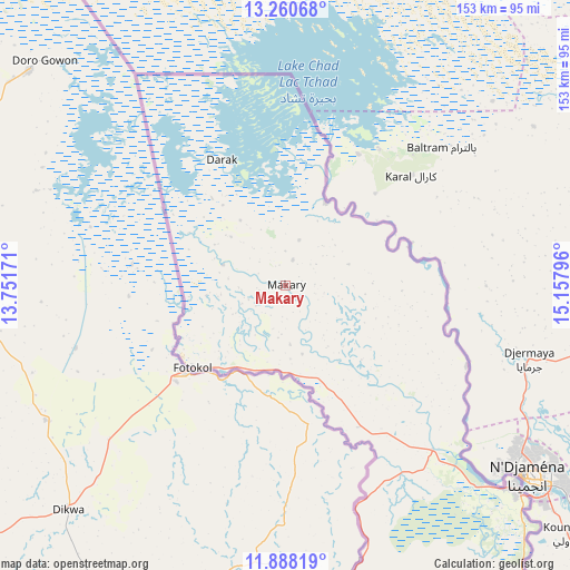
Makary GPS coordinates[2]
12° 34' 31.26" North, 14° 27' 17.388" East
| Map corner | latitude | longitude |
|---|---|---|
| Upper-left | 13.26068°, | 13.75171° |
| Center: | 12.57535°, | 14.45483° |
| Lower-right: | 11.88819°, | 15.15796° |
| Map W x H: | 152.6×152.6 km | = 94.8×94.8mi |
| max Lat: | 12.57535° ⇑0% North |
| Makary: | 12.57535° |
| min Lat: | ⇓100% South 2.35° |
| min Long | Makary | max Long |
| 8.8724° | 14.45483° | 15.23288° |
| W 94.3%⇐ | ⇒5.7% E |
Elevation
Elevation of Makary is 295 m = 968 ft, and this is 378.9 m = 1243 ft below average elevation for this country.
| Max E: |
1687 m = 5535 ft | 77.9% |
| Avg. | 673.9 m = 2211 ft | |
| Makary | 295 m = 968 ft | |
Min E: |
1 m = 3 ft | 22.1% |
See also: Cameroon elevation on elevation.city.
Geographical zone
Makary is located in North Torrid zone (between Equator and Tropic of Cancer). Distance of this Northern Tropic circle is 1207.7 km =750.4 mi to North.| Distance of | km | miles | from Makary |
|---|---|---|---|
| North Pole | 8608.8 | 5349.3 | to North |
| Arctic Circle | 6002.9 | 3730 | to North |
| Tropic Cancer | 1207.7 | 750.4 | to North |
| Equator | 1398.2 | 868.8 | to South |


Nearby cities:
14 places around Makary: (largest is in red/bold)
• Bogo
205.5 km =127.7 mi,  175°
175°
• Garoua
381.9 km =237.3 mi,  197°
197°
• Guider
298.9 km =185.7 mi,  190°
190°
• Kaélé
274.2 km =170.4 mi, 180°
• Kousséri
83.6 km =51.9 mi,  131°
131°
• Koza
199.8 km =124.1 mi, 198°
• Lagdo
400.4 km =248.8 mi, 192°
• Maroua
221.2 km =137.4 mi, 183°
• Mindif
242.2 km =150.5 mi, 180°
• Mokolo
215.8 km =134.1 mi, 199°
• Mora
173.5 km =107.8 mi, 191°
• Pitoa
369.8 km =229.8 mi, 196°
• Rey Bouba
435 km =270.3 mi, 183°
• Yagoua
262.5 km =163.1 mi,  161°
161°
Sources, notices
• [Note1] Compared only with cities in Cameroon existing in our database
• [Src1] Map data: © OpenStreetMap contributors (CC-BY-SA)
• [Src2] Other city data from geonames.org with taken over terms of usage.
• [Src3] Geographical zone / Annual Mean Temperature by Robert A. Rohde @ Wikipedia
