Mindif geodata
Mindif (Far North) is a populated place; located in Cameroon in Africa/Douala (GMT+1) time zone. With population of 10,538 people, there are 70 cities with bigger population in this country. Compared to other cities in Cameroon, 94.3% of cities are located further ↓South; 92.6% of cities are located further ←West and 71.3% of cities have higher elevation than Mindif. Note1


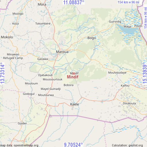
Mindif GPS coordinates[2]
10° 23' 51.252" North, 14° 26' 10.536" East
| Map corner | latitude | longitude |
|---|---|---|
| Upper-left | 11.08837°, | 13.73314° |
| Center: | 10.39757°, | 14.43626° |
| Lower-right: | 9.70524°, | 15.13939° |
| Map W x H: | 153.8×153.8 km | = 95.6×95.6mi |
| max Lat: | 12.57535° ⇑5.7% North |
| Mindif: | 10.39757° |
| min Lat: | ⇓94.3% South 2.35° |
| min Long | Mindif | max Long |
| 8.8724° | 14.43626° | 15.23288° |
| W 92.6%⇐ | ⇒7.4% E |
Elevation
Elevation of Mindif is 396 m = 1299 ft, and this is 277.9 m = 912 ft below average elevation for this country.
| Max E: |
1687 m = 5535 ft | 71.3% |
| Avg. | 673.9 m = 2211 ft | |
| Mindif | 396 m = 1299 ft | |
Min E: |
1 m = 3 ft | 28.7% |
See also: Cameroon elevation on elevation.city.
Geographical zone
Mindif is located in North Torrid zone (between Equator and Tropic of Cancer). Distance of Equator is 1156.1 km =718.4 mi to South.| Distance of | km | miles | from Mindif |
|---|---|---|---|
| North Pole | 8851 | 5499.8 | to North |
| Arctic Circle | 6245.1 | 3880.5 | to North |
| Tropic Cancer | 1449.8 | 900.9 | to North |
| Equator | 1156.1 | 718.4 | to South |


Nearby cities:
15 places around Mindif: (largest is in red/bold)
• Bogo
41.9 km =26 mi,  26°
26°
• Garoua
166.7 km =103.6 mi,  223°
223°
• Guider
74.4 km =46.2 mi,  226°
226°
• Kaélé
32.1 km =19.9 mi,  177°
177°
• Kousséri
197.7 km =122.8 mi,  19°
19°
• Koza
80.1 km =49.8 mi,  310°
310°
• Lagdo
171.2 km =106.4 mi,  209°
209°
• Makary
242.2 km =150.5 mi,  0°
0°
• Maroua
25.2 km =15.7 mi,  328°
328°
• Mokolo
79.2 km =49.2 mi,  298°
298°
• Mora
79 km =49.1 mi,  335°
335°
• Pitoa
152.2 km =94.6 mi, 222°
• Rey Bouba
193.9 km =120.5 mi,  188°
188°
• Tcholliré
223.8 km =139.1 mi, 187°
• Yagoua
87.4 km =54.3 mi,  94°
94°
Sources, notices
• [Note1] Compared only with cities in Cameroon existing in our database
• [Src1] Map data: © OpenStreetMap contributors (CC-BY-SA)
• [Src2] Other city data from geonames.org with taken over terms of usage.
• [Src3] Geographical zone / Annual Mean Temperature by Robert A. Rohde @ Wikipedia
