Maroua geodata
Maroua (Far North) is a seat of a first-order administrative division; located in Cameroon in Africa/Douala (GMT+1) time zone. With population of 319,941 people, there are 5 cities with bigger population in this country. Compared to other cities in Cameroon, 95.1% of cities are located further ↓South; 90.2% of cities are located further ←West and 70.5% of cities have higher elevation than Maroua. Note1


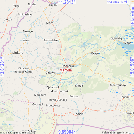
Maroua GPS coordinates[2]
10° 35' 27.42" North, 14° 18' 57.348" East
| Map corner | latitude | longitude |
|---|---|---|
| Upper-left | 11.2813°, | 13.61281° |
| Center: | 10.59095°, | 14.31593° |
| Lower-right: | 9.89904°, | 15.01906° |
| Map W x H: | 153.7×153.7 km | = 95.5×95.5mi |
| max Lat: | 12.57535° ⇑4.9% North |
| Maroua: | 10.59095° |
| min Lat: | ⇓95.1% South 2.35° |
| min Long | Maroua | max Long |
| 8.8724° | 14.31593° | 15.23288° |
| W 90.2%⇐ | ⇒9.8% E |
Elevation
Elevation of Maroua is 406 m = 1332 ft, and this is 267.9 m = 879 ft below average elevation for this country.
| Max E: |
1687 m = 5535 ft | 70.5% |
| Avg. | 673.9 m = 2211 ft | |
| Maroua | 406 m = 1332 ft | |
Min E: |
1 m = 3 ft | 29.5% |
See also: Maroua elevation on elevation.city.
Geographical zone
Maroua is located in North Torrid zone (between Equator and Tropic of Cancer). Distance of Equator is 1177.6 km =731.7 mi to South.| Distance of | km | miles | from Maroua |
|---|---|---|---|
| North Pole | 8829.5 | 5486.4 | to North |
| Arctic Circle | 6223.6 | 3867.2 | to North |
| Tropic Cancer | 1428.3 | 887.5 | to North |
| Equator | 1177.6 | 731.7 | to South |


Nearby cities:
15 places around Maroua: (largest is in red/bold)
• Bogo
35.8 km =22.2 mi,  63°
63°
• Garoua
175.1 km =108.8 mi,  215°
215°
• Guider
83.5 km =51.9 mi,  208°
208°
• Kaélé
55.6 km =34.5 mi,  164°
164°
• Kousséri
182.7 km =113.5 mi,  25°
25°
• Koza
56.6 km =35.2 mi,  303°
303°
• Lagdo
184.7 km =114.8 mi,  202°
202°
• Makary
221.2 km =137.4 mi,  3°
3°
• Mindif
25.2 km =15.7 mi,  148°
148°
• Mokolo
58.6 km =36.4 mi,  286°
286°
• Mora
54.1 km =33.6 mi,  339°
339°
• Pitoa
161.1 km =100.1 mi, 213°
• Rey Bouba
213.9 km =132.9 mi,  184°
184°
• Tcholliré
243.9 km =151.6 mi, 183°
• Yagoua
104 km =64.6 mi,  105°
105°
Sources, notices
• [Note1] Compared only with cities in Cameroon existing in our database
• [Src1] Map data: © OpenStreetMap contributors (CC-BY-SA)
• [Src2] Other city data from geonames.org with taken over terms of usage.
• [Src3] Geographical zone / Annual Mean Temperature by Robert A. Rohde @ Wikipedia
