Rey Bouba geodata
Rey Bouba (North) is a populated place; located in Cameroon in Africa/Douala (GMT+1) time zone. With population of 11,454 people, there are 68 cities with bigger population in this country. Compared to other cities in Cameroon, 88.5% of cities are located further ↓South; 88.5% of cities are located further ←West and 82% of cities have higher elevation than Rey Bouba. Note1


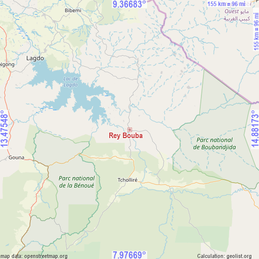
Rey Bouba GPS coordinates[2]
8° 40' 20.64" North, 14° 10' 42.96" East
| Map corner | latitude | longitude |
|---|---|---|
| Upper-left | 9.36683°, | 13.47548° |
| Center: | 8.6724°, | 14.1786° |
| Lower-right: | 7.97669°, | 14.88173° |
| Map W x H: | 154.6×154.6 km | = 96.1×96.1mi |
| max Lat: | 12.57535° ⇑11.5% North |
| Rey Bouba: | 8.6724° |
| min Lat: | ⇓88.5% South 2.35° |
| min Long | Rey Bouba | max Long |
| 8.8724° | 14.1786° | 15.23288° |
| W 88.5%⇐ | ⇒11.5% E |
Elevation
Elevation of Rey Bouba is 235 m = 771 ft, and this is 438.9 m = 1440 ft below average elevation for this country.
| Max E: |
1687 m = 5535 ft | 82% |
| Avg. | 673.9 m = 2211 ft | |
| Rey Bouba | 235 m = 771 ft | |
Min E: |
1 m = 3 ft | 18% |
See also: Cameroon elevation on elevation.city.
Geographical zone
Rey Bouba is located in North Torrid zone (between Equator and Tropic of Cancer). Distance of Equator is 964.3 km =599.2 mi to South.| Distance of | km | miles | from Rey Bouba |
|---|---|---|---|
| North Pole | 9042.8 | 5618.9 | to North |
| Arctic Circle | 6436.9 | 3999.7 | to North |
| Tropic Cancer | 1641.6 | 1020 | to North |
| Equator | 964.3 | 599.2 | to South |


Nearby cities:
15 places around Rey Bouba: (largest is in red/bold)
• Bélel
182.6 km =113.5 mi,  171°
171°
• Djohong
212.4 km =132 mi,  164°
164°
• Garoua
110.7 km =68.8 mi,  309°
309°
• Guider
142.5 km =88.5 mi,  349°
349°
• Kaélé
162.5 km =101 mi,  10°
10°
• Kontcha
227.9 km =141.6 mi,  249°
249°
• Lagdo
70.8 km =44 mi, 307°
• Maroua
213.9 km =132.9 mi,  4°
4°
• Mindif
193.9 km =120.5 mi, 8°
• Ngaoundéré
163.2 km =101.4 mi,  203°
203°
• Pitoa
108.5 km =67.4 mi,  316°
316°
• Poli
105.4 km =65.5 mi,  258°
258°
• Tcholliré
30.1 km =18.7 mi,  181°
181°
• Tignère
222.3 km =138.1 mi,  229°
229°
• Yagoua
218.6 km =135.8 mi,  31°
31°
Sources, notices
• [Note1] Compared only with cities in Cameroon existing in our database
• [Src1] Map data: © OpenStreetMap contributors (CC-BY-SA)
• [Src2] Other city data from geonames.org with taken over terms of usage.
• [Src3] Geographical zone / Annual Mean Temperature by Robert A. Rohde @ Wikipedia
