Koza geodata
Koza (Far North) is a populated place; located in Cameroon in Africa/Douala (GMT+1) time zone. With population of 3,665 people, there are 111 cities with bigger population in this country. Compared to other cities in Cameroon, 97.5% of cities are located further ↓South; 84.4% of cities are located further ←West and 64.8% of cities have higher elevation than Koza. Note1


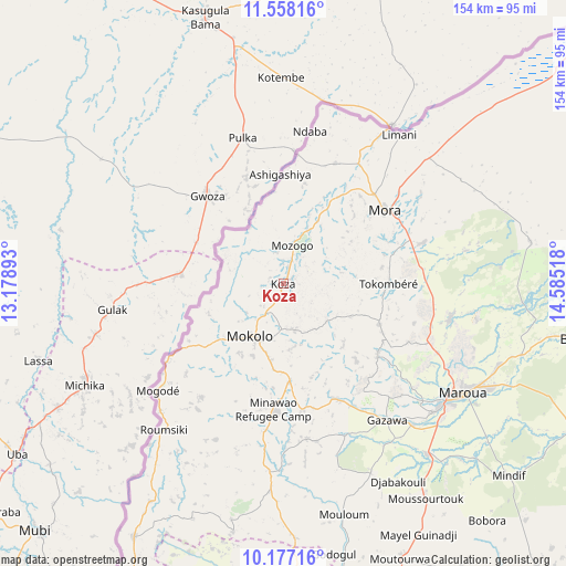
Koza GPS coordinates[2]
10° 52' 6.456" North, 13° 52' 55.38" East
| Map corner | latitude | longitude |
|---|---|---|
| Upper-left | 11.55816°, | 13.17893° |
| Center: | 10.86846°, | 13.88205° |
| Lower-right: | 10.17716°, | 14.58518° |
| Map W x H: | 153.6×153.6 km | = 95.4×95.4mi |
| max Lat: | 12.57535° ⇑2.5% North |
| Koza: | 10.86846° |
| min Lat: | ⇓97.5% South 2.35° |
| min Long | Koza | max Long |
| 8.8724° | 13.88205° | 15.23288° |
| W 84.4%⇐ | ⇒15.6% E |
Elevation
Elevation of Koza is 501 m = 1644 ft, and this is 172.9 m = 567 ft below average elevation for this country.
| Max E: |
1687 m = 5535 ft | 64.8% |
| Avg. | 673.9 m = 2211 ft | |
| Koza | 501 m = 1644 ft | |
Min E: |
1 m = 3 ft | 35.2% |
See also: Cameroon elevation on elevation.city.
Geographical zone
Koza is located in North Torrid zone (between Equator and Tropic of Cancer). Distance of Equator is 1208.5 km =750.9 mi to South.| Distance of | km | miles | from Koza |
|---|---|---|---|
| North Pole | 8798.6 | 5467.2 | to North |
| Arctic Circle | 6192.7 | 3848 | to North |
| Tropic Cancer | 1397.5 | 868.4 | to North |
| Equator | 1208.5 | 750.9 | to South |


Nearby cities:
15 places around Koza: (largest is in red/bold)
• Bogo
80.8 km =50.2 mi,  100°
100°
• Garoua
182.1 km =113.2 mi,  196°
196°
• Guider
104.2 km =64.7 mi,  176°
176°
• Kaélé
104.9 km =65.2 mi,  143°
143°
• Kousséri
183.6 km =114.1 mi,  42°
42°
• Lagdo
202.7 km =126 mi,  186°
186°
• Makary
199.8 km =124.1 mi,  18°
18°
• Maroua
56.6 km =35.2 mi,  123°
123°
• Mindif
80.1 km =49.8 mi,  130°
130°
• Mokolo
16.5 km =10.3 mi,  211°
211°
• Mora
34.4 km =21.4 mi,  54°
54°
• Pitoa
170.2 km =105.8 mi, 194°
• Poli
275.2 km =171 mi, 194°
• Rey Bouba
246.3 km =153 mi,  172°
172°
• Yagoua
158.9 km =98.7 mi,  111°
111°
Sources, notices
• [Note1] Compared only with cities in Cameroon existing in our database
• [Src1] Map data: © OpenStreetMap contributors (CC-BY-SA)
• [Src2] Other city data from geonames.org with taken over terms of usage.
• [Src3] Geographical zone / Annual Mean Temperature by Robert A. Rohde @ Wikipedia
