Lagdo geodata
Lagdo (North) is a populated place; located in Cameroon in Africa/Douala (GMT+1) time zone. With population of 24,596 people, there are 53 cities with bigger population in this country. Compared to other cities in Cameroon, 89.3% of cities are located further ↓South; 82% of cities are located further ←West and 82.8% of cities have higher elevation than Lagdo. Note1


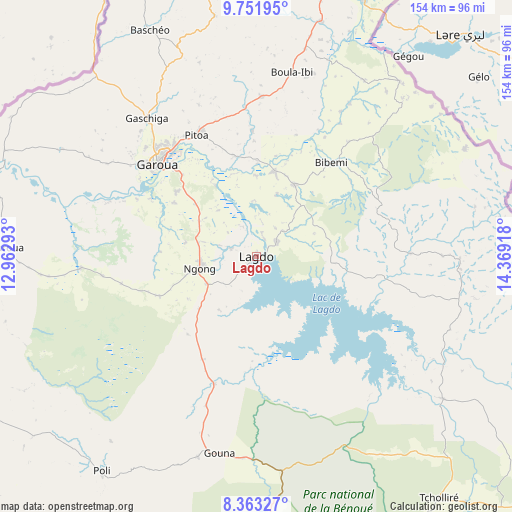
Lagdo GPS coordinates[2]
9° 3' 29.808" North, 13° 39' 57.78" East
| Map corner | latitude | longitude |
|---|---|---|
| Upper-left | 9.75195°, | 12.96293° |
| Center: | 9.05828°, | 13.66605° |
| Lower-right: | 8.36327°, | 14.36918° |
| Map W x H: | 154.4×154.4 km | = 95.9×95.9mi |
| max Lat: | 12.57535° ⇑10.7% North |
| Lagdo: | 9.05828° |
| min Lat: | ⇓89.3% South 2.35° |
| min Long | Lagdo | max Long |
| 8.8724° | 13.66605° | 15.23288° |
| W 82%⇐ | ⇒18% E |
Elevation
Elevation of Lagdo is 234 m = 768 ft, and this is 439.9 m = 1443 ft below average elevation for this country.
| Max E: |
1687 m = 5535 ft | 82.8% |
| Avg. | 673.9 m = 2211 ft | |
| Lagdo | 234 m = 768 ft | |
Min E: |
1 m = 3 ft | 17.2% |
See also: Cameroon elevation on elevation.city.
Geographical zone
Lagdo is located in North Torrid zone (between Equator and Tropic of Cancer). Distance of Equator is 1007.2 km =625.8 mi to South.| Distance of | km | miles | from Lagdo |
|---|---|---|---|
| North Pole | 8999.9 | 5592.3 | to North |
| Arctic Circle | 6394 | 3973 | to North |
| Tropic Cancer | 1598.7 | 993.4 | to North |
| Equator | 1007.2 | 625.8 | to South |


Nearby cities:
15 places around Lagdo: (largest is in red/bold)
• Bogo
213 km =132.4 mi,  29°
29°
• Garoua
40 km =24.9 mi,  312°
312°
• Guider
102 km =63.4 mi,  17°
17°
• Kaélé
145.1 km =90.2 mi,  36°
36°
• Kontcha
198.9 km =123.6 mi,  232°
232°
• Koza
202.7 km =126 mi,  6°
6°
• Maroua
184.7 km =114.8 mi, 22°
• Mindif
171.2 km =106.4 mi, 29°
• Mokolo
187.9 km =116.8 mi,  4°
4°
• Ngaoundéré
192.6 km =119.7 mi,  182°
182°
• Pitoa
40.4 km =25.1 mi,  333°
333°
• Poli
79.9 km =49.6 mi,  215°
215°
• Rey Bouba
70.8 km =44 mi,  127°
127°
• Tcholliré
91.6 km =56.9 mi,  142°
142°
• Tignère
218.8 km =136 mi,  210°
210°
Sources, notices
• [Note1] Compared only with cities in Cameroon existing in our database
• [Src1] Map data: © OpenStreetMap contributors (CC-BY-SA)
• [Src2] Other city data from geonames.org with taken over terms of usage.
• [Src3] Geographical zone / Annual Mean Temperature by Robert A. Rohde @ Wikipedia
