Kousséri geodata
Kousséri (Far North) is a populated place; located in Cameroon in Africa/Douala (GMT+1) time zone. With population of 435,547 people, there are 3 cities with bigger population in this country. Compared to other cities in Cameroon, 99.2% of cities are located further ↓South; 98.4% of cities are located further ←West and 77% of cities have higher elevation than Kousséri. Note1


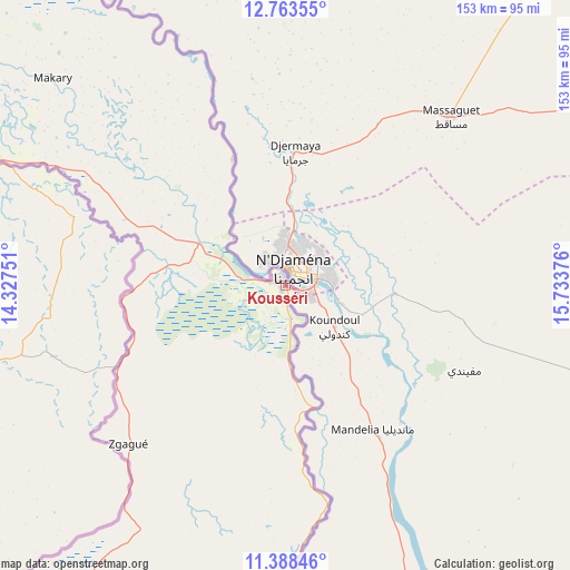
Kousséri GPS coordinates[2]
12° 4' 36.804" North, 15° 1' 50.268" East
| Map corner | latitude | longitude |
|---|---|---|
| Upper-left | 12.76355°, | 14.32751° |
| Center: | 12.07689°, | 15.03063° |
| Lower-right: | 11.38846°, | 15.73376° |
| Map W x H: | 152.9×152.9 km | = 95×95mi |
| max Lat: | 12.57535° ⇑0.8% North |
| Kousséri: | 12.07689° |
| min Lat: | ⇓99.2% South 2.35° |
| min Long | Kousséri | max Long |
| 8.8724° | 15.03063° | 15.23288° |
| W 98.4%⇐ | ⇒1.6% E |
Elevation
Elevation of Kousséri is 300 m = 984 ft, and this is 373.9 m = 1227 ft below average elevation for this country.
| Max E: |
1687 m = 5535 ft | 77% |
| Avg. | 673.9 m = 2211 ft | |
| Kousséri | 300 m = 984 ft | |
Min E: |
1 m = 3 ft | 23% |
See also: Kousséri elevation on elevation.city.
Geographical zone
Kousséri is located in North Torrid zone (between Equator and Tropic of Cancer). Distance of this Northern Tropic circle is 1263.1 km =784.9 mi to North.| Distance of | km | miles | from Kousséri |
|---|---|---|---|
| North Pole | 8664.2 | 5383.7 | to North |
| Arctic Circle | 6058.3 | 3764.5 | to North |
| Tropic Cancer | 1263.1 | 784.9 | to North |
| Equator | 1342.8 | 834.4 | to South |


Nearby cities:
15 places around Kousséri: (largest is in red/bold)
• Bogo
156.3 km =97.1 mi,  197°
197°
• Garoua
356.5 km =221.5 mi,  210°
210°
• Guider
266.1 km =165.3 mi, 206°
• Kaélé
227.8 km =141.5 mi, 196°
• Koza
183.6 km =114.1 mi,  222°
222°
• Lagdo
367.3 km =228.2 mi, 203°
• Makary
83.6 km =51.9 mi,  311°
311°
• Maroua
182.7 km =113.5 mi, 205°
• Mindif
197.7 km =122.8 mi, 199°
• Mokolo
199.8 km =124.1 mi, 222°
• Mora
150.2 km =93.3 mi, 220°
• Pitoa
342.8 km =213 mi, 209°
• Rey Bouba
389.8 km =242.2 mi,  193°
193°
• Tcholliré
419.3 km =260.5 mi, 192°
• Yagoua
194.3 km =120.7 mi,  173°
173°
Sources, notices
• [Note1] Compared only with cities in Cameroon existing in our database
• [Src1] Map data: © OpenStreetMap contributors (CC-BY-SA)
• [Src2] Other city data from geonames.org with taken over terms of usage.
• [Src3] Geographical zone / Annual Mean Temperature by Robert A. Rohde @ Wikipedia
