Guider geodata
Guider (North) is a populated place; located in Cameroon in Africa/Douala (GMT+1) time zone. With population of 84,647 people, there are 18 cities with bigger population in this country. Compared to other cities in Cameroon, 91.8% of cities are located further ↓South; 85.2% of cities are located further ←West and 74.6% of cities have higher elevation than Guider. Note1


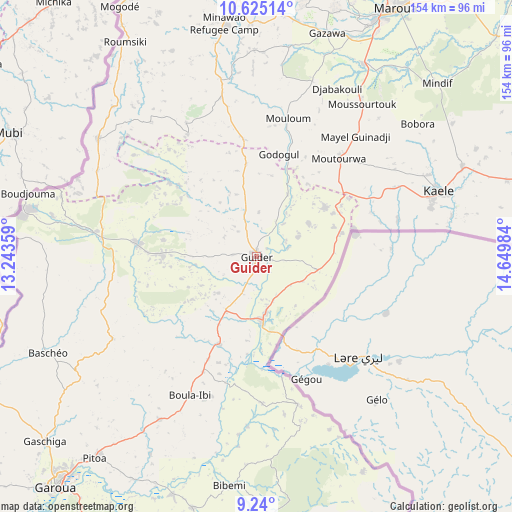
Guider GPS coordinates[2]
9° 55' 59.88" North, 13° 56' 48.156" East
| Map corner | latitude | longitude |
|---|---|---|
| Upper-left | 10.62514°, | 13.24359° |
| Center: | 9.9333°, | 13.94671° |
| Lower-right: | 9.24°, | 14.64984° |
| Map W x H: | 154×154 km | = 95.7×95.7mi |
| max Lat: | 12.57535° ⇑8.2% North |
| Guider: | 9.9333° |
| min Lat: | ⇓91.8% South 2.35° |
| min Long | Guider | max Long |
| 8.8724° | 13.94671° | 15.23288° |
| W 85.2%⇐ | ⇒14.8% E |
Elevation
Elevation of Guider is 346 m = 1135 ft, and this is 327.9 m = 1076 ft below average elevation for this country.
| Max E: |
1687 m = 5535 ft | 74.6% |
| Avg. | 673.9 m = 2211 ft | |
| Guider | 346 m = 1135 ft | |
Min E: |
1 m = 3 ft | 25.4% |
See also: Guider elevation on elevation.city.
Geographical zone
Guider is located in North Torrid zone (between Equator and Tropic of Cancer). Distance of Equator is 1104.5 km =686.3 mi to South.| Distance of | km | miles | from Guider |
|---|---|---|---|
| North Pole | 8902.6 | 5531.8 | to North |
| Arctic Circle | 6296.7 | 3912.6 | to North |
| Tropic Cancer | 1501.4 | 932.9 | to North |
| Equator | 1104.5 | 686.3 | to South |


Nearby cities:
15 places around Guider: (largest is in red/bold)
• Bogo
114.8 km =71.3 mi,  39°
39°
• Garoua
92.5 km =57.5 mi,  220°
220°
• Kaélé
58.6 km =36.4 mi,  70°
70°
• Kousséri
266.1 km =165.3 mi,  26°
26°
• Koza
104.2 km =64.7 mi,  356°
356°
• Lagdo
102 km =63.4 mi,  197°
197°
• Maroua
83.5 km =51.9 mi, 28°
• Mindif
74.4 km =46.2 mi,  46°
46°
• Mokolo
91.3 km =56.7 mi,  350°
350°
• Mora
125.5 km =78 mi,  9°
9°
• Pitoa
78.1 km =48.5 mi, 218°
• Poli
179.6 km =111.6 mi,  205°
205°
• Rey Bouba
142.5 km =88.5 mi,  169°
169°
• Tcholliré
172 km =106.9 mi, 171°
• Yagoua
147.9 km =91.9 mi, 72°
Sources, notices
• [Note1] Compared only with cities in Cameroon existing in our database
• [Src1] Map data: © OpenStreetMap contributors (CC-BY-SA)
• [Src2] Other city data from geonames.org with taken over terms of usage.
• [Src3] Geographical zone / Annual Mean Temperature by Robert A. Rohde @ Wikipedia
