Pitoa geodata
Pitoa (North) is a populated place; located in Cameroon in Africa/Douala (GMT+1) time zone. With population of 11,454 people, there are 68 cities with bigger population in this country. Compared to other cities in Cameroon, 91% of cities are located further ↓South; 79.5% of cities are located further ←West and 85.2% of cities have higher elevation than Pitoa. Note1


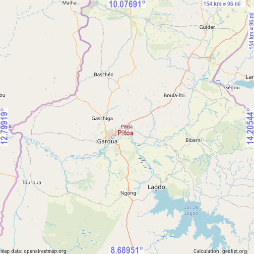
Pitoa GPS coordinates[2]
9° 23' 2.04" North, 13° 30' 8.316" East
| Map corner | latitude | longitude |
|---|---|---|
| Upper-left | 10.07691°, | 12.79919° |
| Center: | 9.3839°, | 13.50231° |
| Lower-right: | 8.68951°, | 14.20544° |
| Map W x H: | 154.3×154.3 km | = 95.9×95.9mi |
| max Lat: | 12.57535° ⇑9% North |
| Pitoa: | 9.3839° |
| min Lat: | ⇓91% South 2.35° |
| min Long | Pitoa | max Long |
| 8.8724° | 13.50231° | 15.23288° |
| W 79.5%⇐ | ⇒20.5% E |
Elevation
Elevation of Pitoa is 187 m = 614 ft, and this is 486.9 m = 1597 ft below average elevation for this country.
| Max E: |
1687 m = 5535 ft | 85.2% |
| Avg. | 673.9 m = 2211 ft | |
| Pitoa | 187 m = 614 ft | |
Min E: |
1 m = 3 ft | 14.8% |
See also: Cameroon elevation on elevation.city.
Geographical zone
Pitoa is located in North Torrid zone (between Equator and Tropic of Cancer). Distance of Equator is 1043.4 km =648.3 mi to South.| Distance of | km | miles | from Pitoa |
|---|---|---|---|
| North Pole | 8963.7 | 5569.8 | to North |
| Arctic Circle | 6357.8 | 3950.6 | to North |
| Tropic Cancer | 1562.5 | 970.9 | to North |
| Equator | 1043.4 | 648.3 | to South |


Nearby cities:
15 places around Pitoa: (largest is in red/bold)
• Bogo
192.9 km =119.9 mi,  38°
38°
• Garoua
14.7 km =9.1 mi,  231°
231°
• Guider
78.1 km =48.5 mi, 38°
• Kaélé
131.6 km =81.8 mi,  52°
52°
• Kontcha
210.4 km =130.7 mi,  221°
221°
• Koza
170.2 km =105.8 mi,  14°
14°
• Lagdo
40.4 km =25.1 mi,  153°
153°
• Maroua
161.1 km =100.1 mi,  33°
33°
• Mindif
152.2 km =94.6 mi, 42°
• Mokolo
154.6 km =96.1 mi, 12°
• Mora
197.6 km =122.8 mi,  20°
20°
• Poli
105 km =65.2 mi,  195°
195°
• Rey Bouba
108.5 km =67.4 mi,  136°
136°
• Tcholliré
131.5 km =81.7 mi, 146°
• Yagoua
217.4 km =135.1 mi,  60°
60°
Sources, notices
• [Note1] Compared only with cities in Cameroon existing in our database
• [Src1] Map data: © OpenStreetMap contributors (CC-BY-SA)
• [Src2] Other city data from geonames.org with taken over terms of usage.
• [Src3] Geographical zone / Annual Mean Temperature by Robert A. Rohde @ Wikipedia
