Tazoult-Lambese geodata
Tazoult-Lambese (Batna) is a populated place; located in Algeria in Africa/Algiers (GMT+1) time zone. With population of 41,636 people, there are 120 cities with bigger population in this country. Compared to other cities in Algeria, 67.1% of cities are located further ↑North; 82.9% of cities are located further ←West and 98.4% of cities have lower elevation than Tazoult-Lambese. Note1


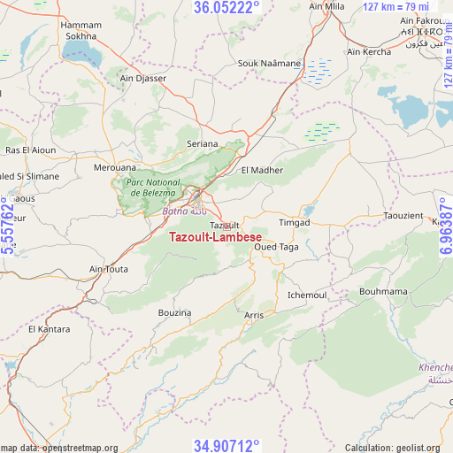
Tazoult-Lambese GPS coordinates[2]
35° 28' 54.156" North, 6° 15' 38.664" East
| Map corner | latitude | longitude |
|---|---|---|
| Upper-left | 36.05222°, | 5.55762° |
| Center: | 35.48171°, | 6.26074° |
| Lower-right: | 34.90712°, | 6.96387° |
| Map W x H: | 127.3×127.3 km | = 79.1×79.1mi |
| max Lat: | 36.92917° ⇑67.1% North |
| Tazoult-Lambese: | 35.48171° |
| min Lat: | ⇓32.9% South 22.785° |
| min Long | Tazoult-Lambese | max Long |
| -8.14743° | 6.26074° | 8.46667° |
| W 82.9%⇐ | ⇒17.1% E |
Elevation
Elevation of Tazoult-Lambese is 1205 m = 3953 ft, and this is 766.5 m = 2515 ft above average elevation for this country.
| Max E: |
1392 m = 4567 ft | 1.6% |
| Tazoult-Lambese | 1205 m 3953 ft | |
| Avg. | 438.5 m = 1439 ft | |
Min E: |
5 m = 16 ft | 98.4% |
See also: Tazoult-Lambese elevation on elevation.city.
Geographical zone
Tazoult-Lambese is located in North temperate zone (between Tropic of Cancer and the Arctic Circle). Distance of this Northern Tropic circle is 1339.3 km =832.2 mi to South.| Distance of | km | miles | from Tazoult-Lambese |
|---|---|---|---|
| North Pole | 6061.9 | 3766.7 | to North |
| Arctic Circle | 3456 | 2147.5 | to North |
| Tropic Cancer | 1339.3 | 832.2 | to South |
| Equator | 3945.2 | 2451.4 | to South |


Nearby cities:
15 places around Tazoult-Lambese: (largest is in red/bold)
• Arris
26 km =16.2 mi,  162°
162°
• Aïn Fakroun
77.6 km =48.2 mi,  45°
45°
• Aïn Kercha
63 km =39.1 mi,  38°
38°
• Aïn Touta
34.7 km =21.6 mi,  250°
250°
• Barika
81.7 km =50.8 mi,  262°
262°
• Batna
11.4 km =7.1 mi,  316°
316°
• Biskra
85.3 km =53 mi,  214°
214°
• Boumagueur
64.2 km =39.9 mi,  272°
272°
• Chelghoum el Aïd
76.2 km =47.3 mi,  353°
353°
• Khenchela
80.1 km =49.8 mi,  93°
93°
• Merouana
35.7 km =22.2 mi,  297°
297°
• Oum el Bouaghi
88.6 km =55.1 mi,  60°
60°
• Râs el Aïoun
59.6 km =37 mi,  290°
290°
• Sidi Okba
88.3 km =54.9 mi,  201°
201°
• Telerghma
71.1 km =44.2 mi,  6°
6°
Sources, notices
• [Note1] Compared only with cities in Algeria existing in our database
• [Src1] Map data: © OpenStreetMap contributors (CC-BY-SA)
• [Src2] Other city data from geonames.org with taken over terms of usage.
• [Src3] Geographical zone / Annual Mean Temperature by Robert A. Rohde @ Wikipedia
