Arris geodata
Arris (Batna) is a populated place; located in Algeria in Africa/Algiers (GMT+1) time zone. With population of 36,641 people, there are 141 cities with bigger population in this country. Compared to other cities in Algeria, 74% of cities are located further ↑North; 84.1% of cities are located further ←West and 98.4% of cities have lower elevation than Arris. Note1


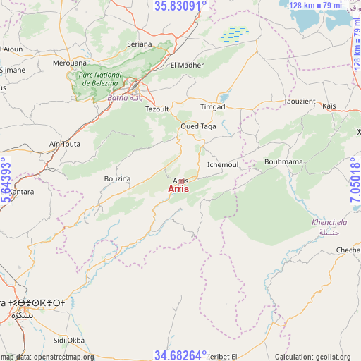
Arris GPS coordinates[2]
35° 15' 31.716" North, 6° 20' 49.416" East
| Map corner | latitude | longitude |
|---|---|---|
| Upper-left | 35.83091°, | 5.64393° |
| Center: | 35.25881°, | 6.34706° |
| Lower-right: | 34.68264°, | 7.05018° |
| Map W x H: | 127.7×127.7 km | = 79.3×79.3mi |
| max Lat: | 36.92917° ⇑74% North |
| Arris: | 35.25881° |
| min Lat: | ⇓26% South 22.785° |
| min Long | Arris | max Long |
| -8.14743° | 6.34706° | 8.46667° |
| W 84.1%⇐ | ⇒15.9% E |
Elevation
Elevation of Arris is 1205 m = 3953 ft, and this is 766.5 m = 2515 ft above average elevation for this country.
| Max E: |
1392 m = 4567 ft | 1.6% |
| Arris | 1205 m 3953 ft | |
| Avg. | 438.5 m = 1439 ft | |
Min E: |
5 m = 16 ft | 98.4% |
See also: Algeria elevation on elevation.city.
Geographical zone
Arris is located in North temperate zone (between Tropic of Cancer and the Arctic Circle). Distance of this Northern Tropic circle is 1314.5 km =816.8 mi to South.| Distance of | km | miles | from Arris |
|---|---|---|---|
| North Pole | 6086.6 | 3782 | to North |
| Arctic Circle | 3480.8 | 2162.9 | to North |
| Tropic Cancer | 1314.5 | 816.8 | to South |
| Equator | 3920.4 | 2436 | to South |


Nearby cities:
15 places around Arris: (largest is in red/bold)
• Aïn Fakroun
92.4 km =57.4 mi,  31°
31°
• Aïn Kercha
80.5 km =50 mi,  23°
23°
• Aïn Touta
42.6 km =26.5 mi,  287°
287°
• Barika
90.2 km =56 mi,  279°
279°
• Batna
36.6 km =22.7 mi,  334°
334°
• Biskra
72.4 km =45 mi,  231°
231°
• Boumagueur
77.1 km =47.9 mi, 290°
• Khenchela
74.9 km =46.5 mi,  74°
74°
• Merouana
57.2 km =35.5 mi,  316°
316°
• Oumache
87.4 km =54.3 mi,  223°
223°
• Râs el Aïoun
78.5 km =48.8 mi,  305°
305°
• Sidi Okba
70.2 km =43.6 mi, 215°
• Tazoult-Lambese
26 km =16.2 mi,  342°
342°
• Telerghma
95.4 km =59.3 mi,  0°
0°
• Zeribet el Oued
65.8 km =40.9 mi,  166°
166°
Sources, notices
• [Note1] Compared only with cities in Algeria existing in our database
• [Src1] Map data: © OpenStreetMap contributors (CC-BY-SA)
• [Src2] Other city data from geonames.org with taken over terms of usage.
• [Src3] Geographical zone / Annual Mean Temperature by Robert A. Rohde @ Wikipedia
