Aïn Touta geodata
Aïn Touta (Batna) is a populated place; located in Algeria in Africa/Algiers (GMT+1) time zone. With population of 72,280 people, there are 54 cities with bigger population in this country. Compared to other cities in Algeria, 71.3% of cities are located further ↑North; 78.7% of cities are located further ←West and 84.9% of cities have lower elevation than Aïn Touta. Note1


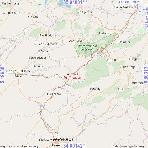
Aïn Touta GPS coordinates[2]
35° 22' 36.3" North, 5° 54' 0.036" East
| Map corner | latitude | longitude |
|---|---|---|
| Upper-left | 35.94801°, | 5.19688° |
| Center: | 35.37675°, | 5.90001° |
| Lower-right: | 34.80142°, | 6.60313° |
| Map W x H: | 127.5×127.5 km | = 79.2×79.2mi |
| max Lat: | 36.92917° ⇑71.3% North |
| Aïn Touta: | 35.37675° |
| min Lat: | ⇓28.7% South 22.785° |
| min Long | Aïn Touta | max Long |
| -8.14743° | 5.90001° | 8.46667° |
| W 78.7%⇐ | ⇒21.3% E |
Elevation
Elevation of Aïn Touta is 925 m = 3035 ft, and this is 486.5 m = 1596 ft above average elevation for this country.
| Max E: |
1392 m = 4567 ft | 15.1% |
| Aïn Touta | 925 m 3035 ft | |
| Avg. | 438.5 m = 1439 ft | |
Min E: |
5 m = 16 ft | 84.9% |
See also: Aïn Touta elevation on elevation.city.
Geographical zone
Aïn Touta is located in North temperate zone (between Tropic of Cancer and the Arctic Circle). Distance of this Northern Tropic circle is 1327.6 km =824.9 mi to South.| Distance of | km | miles | from Aïn Touta |
|---|---|---|---|
| North Pole | 6073.5 | 3773.9 | to North |
| Arctic Circle | 3467.6 | 2154.7 | to North |
| Tropic Cancer | 1327.6 | 824.9 | to South |
| Equator | 3933.5 | 2444.2 | to South |


Nearby cities:
15 places around Aïn Touta: (largest is in red/bold)
• Arris
42.6 km =26.5 mi,  107°
107°
• Barika
48.4 km =30.1 mi,  271°
271°
• Batna
31.8 km =19.8 mi,  51°
51°
• Biskra
60.6 km =37.7 mi,  194°
194°
• Boumagueur
34.6 km =21.5 mi,  294°
294°
• Chelghoum el Aïd
90.7 km =56.4 mi,  15°
15°
• El Eulma
88.3 km =54.9 mi,  347°
347°
• Merouana
28.3 km =17.6 mi,  2°
2°
• Oumache
78.6 km =48.8 mi, 194°
• Râs el Aïoun
40.3 km =25 mi,  325°
325°
• Salah Bey
76.5 km =47.5 mi,  313°
313°
• Sidi Okba
70.2 km =43.6 mi,  180°
180°
• Tazoult-Lambese
34.7 km =21.6 mi,  70°
70°
• Telerghma
91.9 km =57.1 mi,  26°
26°
• Tolga
86.9 km =54 mi,  213°
213°
Sources, notices
• [Note1] Compared only with cities in Algeria existing in our database
• [Src1] Map data: © OpenStreetMap contributors (CC-BY-SA)
• [Src2] Other city data from geonames.org with taken over terms of usage.
• [Src3] Geographical zone / Annual Mean Temperature by Robert A. Rohde @ Wikipedia
