Biskra geodata
Biskra is a seat of a first-order administrative division; located in Algeria in Africa/Algiers (GMT+1) time zone. With population of 307,987 people, there are 5 cities with bigger population in this country. Compared to other cities in Algeria, 81.4% of cities are located further ↑North; 77.5% of cities are located further ←West and 70.5% of cities have higher elevation than Biskra. Note1


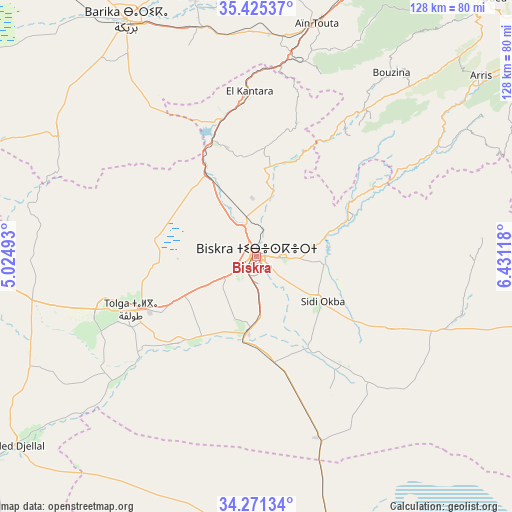
Biskra GPS coordinates[2]
34° 51' 1.368" North, 5° 43' 40.98" East
| Map corner | latitude | longitude |
|---|---|---|
| Upper-left | 35.42537°, | 5.02493° |
| Center: | 34.85038°, | 5.72805° |
| Lower-right: | 34.27134°, | 6.43118° |
| Map W x H: | 128.3×128.3 km | = 79.7×79.7mi |
| max Lat: | 36.92917° ⇑81.4% North |
| Biskra: | 34.85038° |
| min Lat: | ⇓18.6% South 22.785° |
| min Long | Biskra | max Long |
| -8.14743° | 5.72805° | 8.46667° |
| W 77.5%⇐ | ⇒22.5% E |
Elevation
Elevation of Biskra is 115 m = 377 ft, and this is 323.5 m = 1061 ft below average elevation for this country.
| Max E: |
1392 m = 4567 ft | 70.5% |
| Avg. | 438.5 m = 1439 ft | |
| Biskra | 115 m = 377 ft | |
Min E: |
5 m = 16 ft | 29.5% |
See also: Biskra elevation on elevation.city.
Geographical zone
Biskra is located in North temperate zone (between Tropic of Cancer and the Arctic Circle). Distance of this Northern Tropic circle is 1269.1 km =788.6 mi to South.| Distance of | km | miles | from Biskra |
|---|---|---|---|
| North Pole | 6132.1 | 3810.3 | to North |
| Arctic Circle | 3526.2 | 2191.1 | to North |
| Tropic Cancer | 1269.1 | 788.6 | to South |
| Equator | 3875 | 2407.8 | to South |


Nearby cities:
15 places around Biskra: (largest is in red/bold)
• Arris
72.4 km =45 mi,  51°
51°
• Aïn Touta
60.6 km =37.7 mi,  14°
14°
• Barika
68.4 km =42.5 mi,  331°
331°
• Batna
88.3 km =54.9 mi,  27°
27°
• Boumagueur
74.5 km =46.3 mi,  347°
347°
• Merouana
88.4 km =54.9 mi, 10°
• Oumache
18 km =11.2 mi,  193°
193°
• Râs el Aïoun
91.9 km =57.1 mi,  355°
355°
• Râs el Oued
137 km =85.1 mi, 332°
• Salah Bey
118.5 km =73.6 mi,  340°
340°
• Sidi Khaled
85.1 km =52.9 mi,  232°
232°
• Sidi Okba
19.5 km =12.1 mi,  126°
126°
• Tazoult-Lambese
85.3 km =53 mi, 34°
• Tolga
35 km =21.7 mi,  245°
245°
• Zeribet el Oued
73.9 km =45.9 mi,  104°
104°
Sources, notices
• [Note1] Compared only with cities in Algeria existing in our database
• [Src1] Map data: © OpenStreetMap contributors (CC-BY-SA)
• [Src2] Other city data from geonames.org with taken over terms of usage.
• [Src3] Geographical zone / Annual Mean Temperature by Robert A. Rohde @ Wikipedia
