Tolga geodata
Tolga (Biskra) is a populated place; located in Algeria in Africa/Algiers (GMT+1) time zone. With population of 68,246 people, there are 64 cities with bigger population in this country. Compared to other cities in Algeria, 84.1% of cities are located further ↑North; 74% of cities are located further ←West and 62.8% of cities have higher elevation than Tolga. Note1


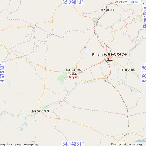
Tolga GPS coordinates[2]
34° 43' 20.064" North, 5° 22' 42.42" East
| Map corner | latitude | longitude |
|---|---|---|
| Upper-left | 35.29813°, | 4.67533° |
| Center: | 34.72224°, | 5.37845° |
| Lower-right: | 34.14231°, | 6.08158° |
| Map W x H: | 128.5×128.5 km | = 79.8×79.8mi |
| max Lat: | 36.92917° ⇑84.1% North |
| Tolga: | 34.72224° |
| min Lat: | ⇓15.9% South 22.785° |
| min Long | Tolga | max Long |
| -8.14743° | 5.37845° | 8.46667° |
| W 74%⇐ | ⇒26% E |
Elevation
Elevation of Tolga is 161 m = 528 ft, and this is 277.5 m = 910 ft below average elevation for this country.
| Max E: |
1392 m = 4567 ft | 62.8% |
| Avg. | 438.5 m = 1439 ft | |
| Tolga | 161 m = 528 ft | |
Min E: |
5 m = 16 ft | 37.2% |
See also: Tolga elevation on elevation.city.
Geographical zone
Tolga is located in North temperate zone (between Tropic of Cancer and the Arctic Circle). Distance of this Northern Tropic circle is 1254.8 km =779.7 mi to South.| Distance of | km | miles | from Tolga |
|---|---|---|---|
| North Pole | 6146.3 | 3819.1 | to North |
| Arctic Circle | 3540.4 | 2199.9 | to North |
| Tropic Cancer | 1254.8 | 779.7 | to South |
| Equator | 3860.8 | 2399 | to South |


Nearby cities:
15 places around Tolga: (largest is in red/bold)
• Arris
106.5 km =66.2 mi,  55°
55°
• Aïn Touta
86.9 km =54 mi,  33°
33°
• Barika
74.1 km =46 mi,  359°
359°
• Batna
117.6 km =73.1 mi,  37°
37°
• Biskra
35 km =21.7 mi,  65°
65°
• Boumagueur
88.5 km =55 mi,  10°
10°
• Merouana
112.1 km =69.7 mi, 25°
• Oumache
27.8 km =17.3 mi,  96°
96°
• Râs el Aïoun
108.6 km =67.5 mi, 12°
• Salah Bey
126.1 km =78.4 mi, 356°
• Sidi Khaled
51.7 km =32.1 mi,  223°
223°
• Sidi Okba
47.6 km =29.6 mi,  86°
86°
• Tazoult-Lambese
116.5 km =72.4 mi, 43°
• Zeribet el Oued
103.6 km =64.4 mi, 92°
• ’Aïn el Melh
111.7 km =69.4 mi,  276°
276°
Sources, notices
• [Note1] Compared only with cities in Algeria existing in our database
• [Src1] Map data: © OpenStreetMap contributors (CC-BY-SA)
• [Src2] Other city data from geonames.org with taken over terms of usage.
• [Src3] Geographical zone / Annual Mean Temperature by Robert A. Rohde @ Wikipedia
