Sidi Okba geodata
Sidi Okba (Biskra) is a populated place; located in Algeria in Africa/Algiers (GMT+1) time zone. With population of 34,985 people, there are 147 cities with bigger population in this country. Compared to other cities in Algeria, 83.3% of cities are located further ↑North; 78.3% of cities are located further ←West and 86% of cities have higher elevation than Sidi Okba. Note1


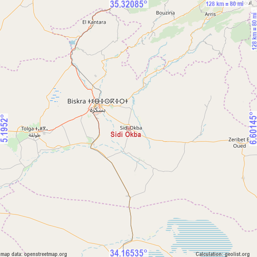
Sidi Okba GPS coordinates[2]
34° 44' 42.432" North, 5° 53' 53.988" East
| Map corner | latitude | longitude |
|---|---|---|
| Upper-left | 35.32085°, | 5.1952° |
| Center: | 34.74512°, | 5.89833° |
| Lower-right: | 34.16535°, | 6.60145° |
| Map W x H: | 128.5×128.5 km | = 79.8×79.8mi |
| max Lat: | 36.92917° ⇑83.3% North |
| Sidi Okba: | 34.74512° |
| min Lat: | ⇓16.7% South 22.785° |
| min Long | Sidi Okba | max Long |
| -8.14743° | 5.89833° | 8.46667° |
| W 78.3%⇐ | ⇒21.7% E |
Elevation
Elevation of Sidi Okba is 53 m = 174 ft, and this is 385.5 m = 1265 ft below average elevation for this country.
| Max E: |
1392 m = 4567 ft | 86% |
| Avg. | 438.5 m = 1439 ft | |
| Sidi Okba | 53 m = 174 ft | |
Min E: |
5 m = 16 ft | 14% |
See also: Algeria elevation on elevation.city.
Geographical zone
Sidi Okba is located in North temperate zone (between Tropic of Cancer and the Arctic Circle). Distance of this Northern Tropic circle is 1257.4 km =781.3 mi to South.| Distance of | km | miles | from Sidi Okba |
|---|---|---|---|
| North Pole | 6143.8 | 3817.6 | to North |
| Arctic Circle | 3537.9 | 2198.3 | to North |
| Tropic Cancer | 1257.4 | 781.3 | to South |
| Equator | 3863.3 | 2400.5 | to South |


Nearby cities:
15 places around Sidi Okba: (largest is in red/bold)
• Arris
70.2 km =43.6 mi,  35°
35°
• Aïn Touta
70.2 km =43.6 mi,  0°
0°
• Barika
86.5 km =53.7 mi,  325°
325°
• Batna
93.6 km =58.2 mi,  15°
15°
• Biskra
19.5 km =12.1 mi,  306°
306°
• Boumagueur
90.2 km =56 mi,  339°
339°
• Djamaa
135 km =83.9 mi,  176°
176°
• Merouana
98.5 km =61.2 mi, 0°
• Oumache
20.7 km =12.9 mi,  253°
253°
• Râs el Aïoun
105.8 km =65.7 mi,  347°
347°
• Salah Bey
135.1 km =83.9 mi, 335°
• Sidi Khaled
92.4 km =57.4 mi,  244°
244°
• Tazoult-Lambese
88.3 km =54.9 mi, 21°
• Tolga
47.6 km =29.6 mi,  266°
266°
• Zeribet el Oued
56.4 km =35 mi,  97°
97°
Sources, notices
• [Note1] Compared only with cities in Algeria existing in our database
• [Src1] Map data: © OpenStreetMap contributors (CC-BY-SA)
• [Src2] Other city data from geonames.org with taken over terms of usage.
• [Src3] Geographical zone / Annual Mean Temperature by Robert A. Rohde @ Wikipedia
