Zaruma geodata
Zaruma (El Oro) is a populated place; located in Ecuador in America/Guayaquil (GMT-5) time zone. With population of 12,505 people, there are 76 cities with bigger population in this country. Compared to other cities in Ecuador, 92.6% of cities are located further ↑North; 57% of cities are located further →East and 67.8% of cities have lower elevation than Zaruma. Note1


Zaruma GPS coordinates[2]
3° 41' 28.752" South, 79° 36' 42.264" West
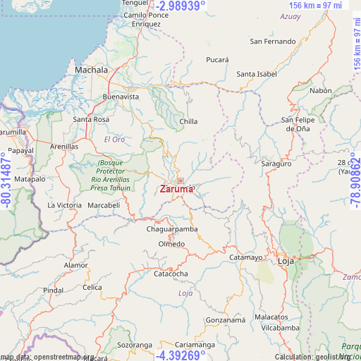
| Map corner | latitude | longitude |
|---|---|---|
| Upper-left | -2.98939°, | -80.31487° |
| Center: | -3.69132°, | -79.61174° |
| Lower-right: | -4.39269°, | -78.90862° |
| Map W x H: | 156×156 km | = 96.9×96.9mi |
| max Lat: | 1.35251° ⇑92.6% North |
| Zaruma: | -3.69132° |
| min Lat: | ⇓7.4% South -4.38181° |
| min Long | Zaruma | max Long |
| -90.96654° | -79.61174° | -76.89528° |
| W 43%⇐ | ⇒57% E |
Elevation
Elevation of Zaruma is 1198 m = 3930 ft, and this is 252.9 m = 830 ft above average elevation for this country.
| Max E: |
3131 m = 10272 ft | 32.2% |
| Zaruma | 1198 m 3930 ft | |
| Avg. | 945.1 m = 3101 ft | |
Min E: |
1 m = 3 ft | 67.8% |
See also: Ecuador elevation on elevation.city.
Geographical zone
Zaruma is located in South Torrid zone (between Equator and Tropic of Capricorn). Distance of Equator is 410.4 km =255 mi to North.| Distance of | km | miles | from Zaruma |
|---|---|---|---|
| Equator | 410.4 | 255 | to North |
| Tropic Capricorn | 2195.5 | 1364.2 | to South |
| Antarctic Circle | 6990.7 | 4343.8 | to South |
| South Pole | 9596.6 | 5963 | to South |


Nearby cities:
15 places around Zaruma: (largest is in red/bold)
• Baláo
89.6 km =55.7 mi,  345°
345°
• Cariamanga
71.1 km =44.2 mi,  174°
174°
• Catacocha
40.1 km =24.9 mi,  185°
185°
• Catamayo
43.2 km =26.8 mi,  139°
139°
• Celica
59.6 km =37 mi,  219°
219°
• Huaquillas
72.8 km =45.2 mi,  289°
289°
• Loja
56.3 km =35 mi,  126°
126°
• Macará
85.1 km =52.9 mi,  205°
205°
• Machala
61.8 km =38.4 mi,  321°
321°
• Pasaje
46.1 km =28.6 mi,  331°
331°
• Piñas
7.8 km =4.8 mi,  278°
278°
• Portovelo
3.5 km =2.2 mi,  198°
198°
• Puerto Bolívar
63.8 km =39.6 mi, 317°
• Santa Rosa
47.1 km =29.3 mi,  304°
304°
• Zamora
84 km =52.2 mi,  119°
119°
Sources, notices
• [Note1] Compared only with cities in Ecuador existing in our database
• [Src1] Map data: © OpenStreetMap contributors (CC-BY-SA)
• [Src2] Other city data from geonames.org with taken over terms of usage.
• [Src3] Geographical zone / Annual Mean Temperature by Robert A. Rohde @ Wikipedia
