Cariamanga geodata
Cariamanga (Loja) is a populated place; located in Ecuador in America/Guayaquil (GMT-5) time zone. With population of 16,862 people, there are 59 cities with bigger population in this country. Compared to other cities in Ecuador, 99.2% of cities are located further ↑North; 55.4% of cities are located further →East and 71.1% of cities have lower elevation than Cariamanga. Note1


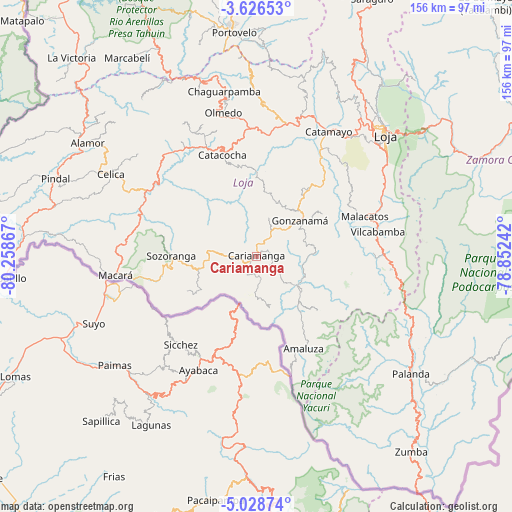
Cariamanga GPS coordinates[2]
4° 19' 40.656" South, 79° 33' 19.944" West
| Map corner | latitude | longitude |
|---|---|---|
| Upper-left | -3.62653°, | -80.25867° |
| Center: | -4.32796°, | -79.55554° |
| Lower-right: | -5.02874°, | -78.85242° |
| Map W x H: | 155.9×155.9 km | = 96.9×96.9mi |
| max Lat: | 1.35251° ⇑99.2% North |
| Cariamanga: | -4.32796° |
| min Lat: | ⇓0.8% South -4.38181° |
| min Long | Cariamanga | max Long |
| -90.96654° | -79.55554° | -76.89528° |
| W 44.6%⇐ | ⇒55.4% E |
Elevation
Elevation of Cariamanga is 1946 m = 6385 ft, and this is 1000.9 m = 3284 ft above average elevation for this country.
| Max E: |
3131 m = 10272 ft | 28.9% |
| Cariamanga | 1946 m 6385 ft | |
| Avg. | 945.1 m = 3101 ft | |
Min E: |
1 m = 3 ft | 71.1% |
See also: Ecuador elevation on elevation.city.
Geographical zone
Cariamanga is located in South Torrid zone (between Equator and Tropic of Capricorn). Distance of Equator is 481.2 km =299 mi to North.| Distance of | km | miles | from Cariamanga |
|---|---|---|---|
| Equator | 481.2 | 299 | to North |
| Tropic Capricorn | 2124.7 | 1320.2 | to South |
| Antarctic Circle | 6920 | 4299.9 | to South |
| South Pole | 9525.8 | 5919.1 | to South |


Nearby cities:
15 places around Cariamanga: (largest is in red/bold)
• Catacocha
32.6 km =20.3 mi,  341°
341°
• Catamayo
43.8 km =27.2 mi,  29°
29°
• Celica
51 km =31.7 mi,  299°
299°
• Huaquillas
120.8 km =75.1 mi,  321°
321°
• Loja
53.9 km =33.5 mi,  46°
46°
• Macará
43.4 km =27 mi,  262°
262°
• Machala
127.1 km =79 mi, 339°
• Pasaje
114.9 km =71.4 mi,  345°
345°
• Piñas
73.3 km =45.5 mi, 349°
• Portovelo
67.8 km =42.1 mi, 353°
• Puerto Bolívar
127.8 km =79.4 mi, 337°
• Santa Rosa
107.5 km =66.8 mi, 335°
• Yantzaza
103.9 km =64.6 mi,  58°
58°
• Zamora
72.7 km =45.2 mi,  66°
66°
• Zaruma
71.1 km =44.2 mi, 354°
Sources, notices
• [Note1] Compared only with cities in Ecuador existing in our database
• [Src1] Map data: © OpenStreetMap contributors (CC-BY-SA)
• [Src2] Other city data from geonames.org with taken over terms of usage.
• [Src3] Geographical zone / Annual Mean Temperature by Robert A. Rohde @ Wikipedia
