Piñas geodata
Piñas (El Oro) is a populated place; located in Ecuador in America/Guayaquil (GMT-5) time zone. With population of 16,981 people, there are 58 cities with bigger population in this country. Compared to other cities in Ecuador, 91.7% of cities are located further ↑North; 63.6% of cities are located further →East and 66.9% of cities have lower elevation than Piñas. Note1


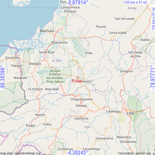
Piñas GPS coordinates[2]
3° 40' 51.852" South, 79° 40' 50.988" West
| Map corner | latitude | longitude |
|---|---|---|
| Upper-left | -2.97914°, | -80.38396° |
| Center: | -3.68107°, | -79.68083° |
| Lower-right: | -4.38245°, | -78.97771° |
| Map W x H: | 156×156 km | = 96.9×96.9mi |
| max Lat: | 1.35251° ⇑91.7% North |
| Piñas: | -3.68107° |
| min Lat: | ⇓8.3% South -4.38181° |
| min Long | Piñas | max Long |
| -90.96654° | -79.68083° | -76.89528° |
| W 36.4%⇐ | ⇒63.6% E |
Elevation
Elevation of Piñas is 1017 m = 3337 ft, and this is 71.9 m = 236 ft above average elevation for this country.
| Max E: |
3131 m = 10272 ft | 33.1% |
| Piñas | 1017 m 3337 ft | |
| Avg. | 945.1 m = 3101 ft | |
Min E: |
1 m = 3 ft | 66.9% |
See also: Ecuador elevation on elevation.city.
Geographical zone
Piñas is located in South Torrid zone (between Equator and Tropic of Capricorn). Distance of Equator is 409.3 km =254.3 mi to North.| Distance of | km | miles | from Piñas |
|---|---|---|---|
| Equator | 409.3 | 254.3 | to North |
| Tropic Capricorn | 2196.6 | 1364.9 | to South |
| Antarctic Circle | 6991.9 | 4344.6 | to South |
| South Pole | 9597.8 | 5963.8 | to South |


Nearby cities:
15 places around Piñas: (largest is in red/bold)
• Baláo
86.9 km =54 mi,  350°
350°
• Cariamanga
73.3 km =45.5 mi,  169°
169°
• Catacocha
41.1 km =25.5 mi,  175°
175°
• Catamayo
49.3 km =30.6 mi,  133°
133°
• Celica
56 km =34.8 mi,  213°
213°
• Huaquillas
65.2 km =40.5 mi,  290°
290°
• Loja
63.2 km =39.3 mi,  123°
123°
• Macará
83.2 km =51.7 mi,  200°
200°
• Machala
56.3 km =35 mi,  326°
326°
• Pasaje
41.9 km =26 mi,  340°
340°
• Portovelo
7.9 km =4.9 mi, 124°
• Puerto Bolívar
58 km =36 mi,  322°
322°
• Santa Rosa
40.3 km =25 mi,  309°
309°
• Zamora
91.2 km =56.7 mi, 118°
• Zaruma
7.8 km =4.8 mi,  98°
98°
Sources, notices
• [Note1] Compared only with cities in Ecuador existing in our database
• [Src1] Map data: © OpenStreetMap contributors (CC-BY-SA)
• [Src2] Other city data from geonames.org with taken over terms of usage.
• [Src3] Geographical zone / Annual Mean Temperature by Robert A. Rohde @ Wikipedia
