Loja geodata
Loja is a seat of a first-order administrative division; located in Ecuador in America/Guayaquil (GMT-5) time zone. With population of 117,796 people, there are 15 cities with bigger population in this country. Compared to other cities in Ecuador, 95.9% of cities are located further ↑North; 55.4% of cities are located further ←West and 72.7% of cities have lower elevation than Loja. Note1


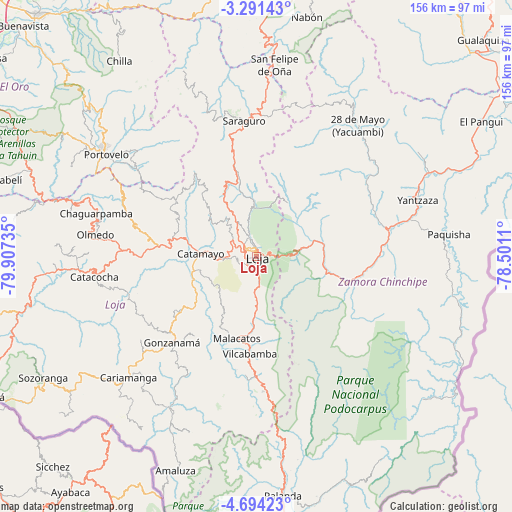
Loja GPS coordinates[2]
3° 59' 35.268" South, 79° 12' 15.192" West
| Map corner | latitude | longitude |
|---|---|---|
| Upper-left | -3.29143°, | -79.90735° |
| Center: | -3.99313°, | -79.20422° |
| Lower-right: | -4.69423°, | -78.5011° |
| Map W x H: | 156×156 km | = 96.9×96.9mi |
| max Lat: | 1.35251° ⇑95.9% North |
| Loja: | -3.99313° |
| min Lat: | ⇓4.1% South -4.38181° |
| min Long | Loja | max Long |
| -90.96654° | -79.20422° | -76.89528° |
| W 55.4%⇐ | ⇒44.6% E |
Elevation
Elevation of Loja is 2060 m = 6759 ft, and this is 1114.9 m = 3658 ft above average elevation for this country.
| Max E: |
3131 m = 10272 ft | 27.3% |
| Loja | 2060 m 6759 ft | |
| Avg. | 945.1 m = 3101 ft | |
Min E: |
1 m = 3 ft | 72.7% |
See also: Loja elevation on elevation.city.
Geographical zone
Loja is located in South Torrid zone (between Equator and Tropic of Capricorn). Distance of Equator is 444 km =275.9 mi to North.| Distance of | km | miles | from Loja |
|---|---|---|---|
| Equator | 444 | 275.9 | to North |
| Tropic Capricorn | 2161.9 | 1343.3 | to South |
| Antarctic Circle | 6957.2 | 4323 | to South |
| South Pole | 9563.1 | 5942.2 | to South |


Nearby cities:
15 places around Loja: (largest is in red/bold)
• Cariamanga
53.9 km =33.5 mi,  226°
226°
• Catacocha
49.8 km =30.9 mi,  262°
262°
• Catamayo
17.2 km =10.7 mi,  272°
272°
• Celica
84.3 km =52.4 mi, 261°
• Gualaquiza
95.2 km =59.2 mi,  46°
46°
• Macará
92.7 km =57.6 mi,  242°
242°
• Machala
117.1 km =72.8 mi,  314°
314°
• Pasaje
99.9 km =62.1 mi,  317°
317°
• Piñas
63.2 km =39.3 mi,  303°
303°
• Portovelo
55.3 km =34.4 mi, 303°
• Puerto Bolívar
119.5 km =74.3 mi, 312°
• Santa Rosa
103.4 km =64.2 mi, 305°
• Yantzaza
52.3 km =32.5 mi,  70°
70°
• Zamora
28.8 km =17.9 mi,  106°
106°
• Zaruma
56.3 km =35 mi, 306°
Sources, notices
• [Note1] Compared only with cities in Ecuador existing in our database
• [Src1] Map data: © OpenStreetMap contributors (CC-BY-SA)
• [Src2] Other city data from geonames.org with taken over terms of usage.
• [Src3] Geographical zone / Annual Mean Temperature by Robert A. Rohde @ Wikipedia
