Portovelo geodata
Portovelo (El Oro) is a populated place; located in Ecuador in America/Guayaquil (GMT-5) time zone. With population of 9,708 people, there are 85 cities with bigger population in this country. Compared to other cities in Ecuador, 93.4% of cities are located further ↑North; 58.7% of cities are located further →East and 60.3% of cities have lower elevation than Portovelo. Note1


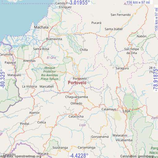
Portovelo GPS coordinates[2]
3° 43' 17.22" South, 79° 37' 18.732" West
| Map corner | latitude | longitude |
|---|---|---|
| Upper-left | -3.01955°, | -80.325° |
| Center: | -3.72145°, | -79.62187° |
| Lower-right: | -4.4228°, | -78.91875° |
| Map W x H: | 156×156 km | = 96.9×96.9mi |
| max Lat: | 1.35251° ⇑93.4% North |
| Portovelo: | -3.72145° |
| min Lat: | ⇓6.6% South -4.38181° |
| min Long | Portovelo | max Long |
| -90.96654° | -79.62187° | -76.89528° |
| W 41.3%⇐ | ⇒58.7% E |
Elevation
Elevation of Portovelo is 621 m = 2037 ft, and this is 324.1 m = 1063 ft below average elevation for this country.
| Max E: |
3131 m = 10272 ft | 39.7% |
| Avg. | 945.1 m = 3101 ft | |
| Portovelo | 621 m = 2037 ft | |
Min E: |
1 m = 3 ft | 60.3% |
See also: Ecuador elevation on elevation.city.
Geographical zone
Portovelo is located in South Torrid zone (between Equator and Tropic of Capricorn). Distance of Equator is 413.8 km =257.1 mi to North.| Distance of | km | miles | from Portovelo |
|---|---|---|---|
| Equator | 413.8 | 257.1 | to North |
| Tropic Capricorn | 2192.1 | 1362.1 | to South |
| Antarctic Circle | 6987.4 | 4341.8 | to South |
| South Pole | 9593.3 | 5961 | to South |


Nearby cities:
15 places around Portovelo: (largest is in red/bold)
• Baláo
92.6 km =57.5 mi,  346°
346°
• Cariamanga
67.8 km =42.1 mi,  173°
173°
• Catacocha
36.6 km =22.7 mi,  184°
184°
• Catamayo
41.5 km =25.8 mi,  135°
135°
• Celica
56.4 km =35 mi,  221°
221°
• Huaquillas
72.9 km =45.3 mi,  292°
292°
• Loja
55.3 km =34.4 mi,  123°
123°
• Macará
81.6 km =50.7 mi,  205°
205°
• Machala
63.7 km =39.6 mi,  323°
323°
• Pasaje
48.6 km =30.2 mi,  334°
334°
• Piñas
7.9 km =4.9 mi,  304°
304°
• Puerto Bolívar
65.6 km =40.8 mi, 320°
• Santa Rosa
48.2 km =30 mi,  308°
308°
• Zamora
83.4 km =51.8 mi, 117°
• Zaruma
3.5 km =2.2 mi,  18°
18°
Sources, notices
• [Note1] Compared only with cities in Ecuador existing in our database
• [Src1] Map data: © OpenStreetMap contributors (CC-BY-SA)
• [Src2] Other city data from geonames.org with taken over terms of usage.
• [Src3] Geographical zone / Annual Mean Temperature by Robert A. Rohde @ Wikipedia
