Catacocha geodata
Catacocha (Loja) is a populated place; located in Ecuador in America/Guayaquil (GMT-5) time zone. With population of 10,872 people, there are 79 cities with bigger population in this country. Compared to other cities in Ecuador, 96.7% of cities are located further ↑North; 61.2% of cities are located further →East and 70.2% of cities have lower elevation than Catacocha. Note1


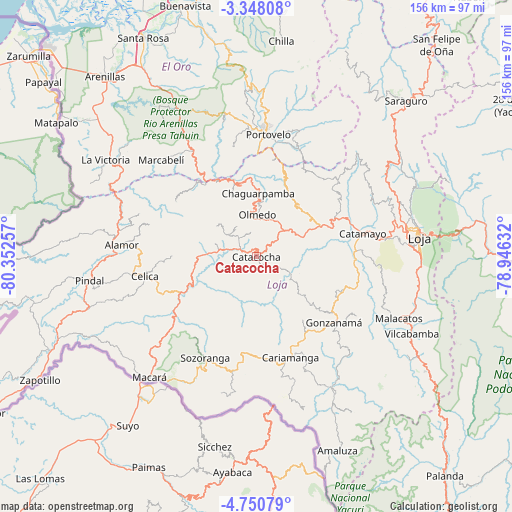
Catacocha GPS coordinates[2]
4° 2' 59.064" South, 79° 38' 57.984" West
| Map corner | latitude | longitude |
|---|---|---|
| Upper-left | -3.34808°, | -80.35257° |
| Center: | -4.04974°, | -79.64944° |
| Lower-right: | -4.75079°, | -78.94632° |
| Map W x H: | 156×156 km | = 96.9×96.9mi |
| max Lat: | 1.35251° ⇑96.7% North |
| Catacocha: | -4.04974° |
| min Lat: | ⇓3.3% South -4.38181° |
| min Long | Catacocha | max Long |
| -90.96654° | -79.64944° | -76.89528° |
| W 38.8%⇐ | ⇒61.2% E |
Elevation
Elevation of Catacocha is 1874 m = 6148 ft, and this is 928.9 m = 3048 ft above average elevation for this country.
| Max E: |
3131 m = 10272 ft | 29.8% |
| Catacocha | 1874 m 6148 ft | |
| Avg. | 945.1 m = 3101 ft | |
Min E: |
1 m = 3 ft | 70.2% |
See also: Ecuador elevation on elevation.city.
Geographical zone
Catacocha is located in South Torrid zone (between Equator and Tropic of Capricorn). Distance of Equator is 450.3 km =279.8 mi to North.| Distance of | km | miles | from Catacocha |
|---|---|---|---|
| Equator | 450.3 | 279.8 | to North |
| Tropic Capricorn | 2155.6 | 1339.4 | to South |
| Antarctic Circle | 6950.9 | 4319.1 | to South |
| South Pole | 9556.8 | 5938.3 | to South |


Nearby cities:
15 places around Catacocha: (largest is in red/bold)
• Cariamanga
32.6 km =20.3 mi,  161°
161°
• Catamayo
33 km =20.5 mi,  77°
77°
• Celica
34.6 km =21.5 mi,  260°
260°
• Huaquillas
90.8 km =56.4 mi,  314°
314°
• Loja
49.8 km =30.9 mi, 82°
• Macará
49.3 km =30.6 mi,  221°
221°
• Machala
94.5 km =58.7 mi,  338°
338°
• Pasaje
82.4 km =51.2 mi,  347°
347°
• Piñas
41.1 km =25.5 mi,  355°
355°
• Portovelo
36.6 km =22.7 mi,  4°
4°
• Puerto Bolívar
95.3 km =59.2 mi, 336°
• Santa Rosa
75.2 km =46.7 mi,  332°
332°
• Yantzaza
101.5 km =63.1 mi, 76°
• Zamora
77.1 km =47.9 mi,  91°
91°
• Zaruma
40.1 km =24.9 mi,  5°
5°
Sources, notices
• [Note1] Compared only with cities in Ecuador existing in our database
• [Src1] Map data: © OpenStreetMap contributors (CC-BY-SA)
• [Src2] Other city data from geonames.org with taken over terms of usage.
• [Src3] Geographical zone / Annual Mean Temperature by Robert A. Rohde @ Wikipedia
