Zamora geodata
Zamora (Zamora-Chinchipe) is a seat of a first-order administrative division; located in Ecuador in America/Guayaquil (GMT-5) time zone. With population of 15,276 people, there are 65 cities with bigger population in this country. Compared to other cities in Ecuador, 97.5% of cities are located further ↑North; 60.3% of cities are located further ←West and 65.3% of cities have lower elevation than Zamora. Note1


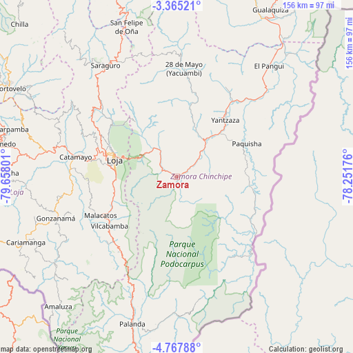
Zamora GPS coordinates[2]
4° 4' 0.66" South, 78° 57' 17.568" West
| Map corner | latitude | longitude |
|---|---|---|
| Upper-left | -3.36521°, | -79.65801° |
| Center: | -4.06685°, | -78.95488° |
| Lower-right: | -4.76788°, | -78.25176° |
| Map W x H: | 156×156 km | = 96.9×96.9mi |
| max Lat: | 1.35251° ⇑97.5% North |
| Zamora: | -4.06685° |
| min Lat: | ⇓2.5% South -4.38181° |
| min Long | Zamora | max Long |
| -90.96654° | -78.95488° | -76.89528° |
| W 60.3%⇐ | ⇒39.7% E |
Elevation
Elevation of Zamora is 918 m = 3012 ft, and this is 27.1 m = 89 ft below average elevation for this country.
| Max E: |
3131 m = 10272 ft | 34.7% |
| Avg. | 945.1 m = 3101 ft | |
| Zamora | 918 m = 3012 ft | |
Min E: |
1 m = 3 ft | 65.3% |
See also: Ecuador elevation on elevation.city.
Geographical zone
Zamora is located in South Torrid zone (between Equator and Tropic of Capricorn). Distance of Equator is 452.2 km =281 mi to North.| Distance of | km | miles | from Zamora |
|---|---|---|---|
| Equator | 452.2 | 281 | to North |
| Tropic Capricorn | 2153.7 | 1338.2 | to South |
| Antarctic Circle | 6949 | 4317.9 | to South |
| South Pole | 9554.9 | 5937.1 | to South |


Nearby cities:
15 places around Zamora: (largest is in red/bold)
• Cariamanga
72.7 km =45.2 mi,  246°
246°
• Catacocha
77.1 km =47.9 mi,  271°
271°
• Catamayo
45.7 km =28.4 mi,  281°
281°
• Celica
111.2 km =69.1 mi, 267°
• Cuenca
129.8 km =80.7 mi,  357°
357°
• Gualaquiza
84.6 km =52.6 mi,  29°
29°
• Loja
28.8 km =17.9 mi,  286°
286°
• Macará
115.1 km =71.5 mi, 252°
• Nulti
128.4 km =79.8 mi,  5°
5°
• Pasaje
125.4 km =77.9 mi,  311°
311°
• Piñas
91.2 km =56.7 mi,  298°
298°
• Portovelo
83.4 km =51.8 mi, 297°
• Santa Rosa
130.9 km =81.3 mi, 301°
• Yantzaza
33.8 km =21 mi,  39°
39°
• Zaruma
84 km =52.2 mi, 299°
Sources, notices
• [Note1] Compared only with cities in Ecuador existing in our database
• [Src1] Map data: © OpenStreetMap contributors (CC-BY-SA)
• [Src2] Other city data from geonames.org with taken over terms of usage.
• [Src3] Geographical zone / Annual Mean Temperature by Robert A. Rohde @ Wikipedia
